United
Nations
Office for Outer Space Affairs
UN-SPIDER Knowledge Portal
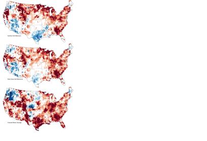
A deep and persistent drought struck vast portions of the continental United States in 2012. Though there has been some relief in the late summer, a pair of satellites operated by NASA shows that the drought lingers in the underground water supplies that are often tapped for drinking water and farming. The maps combine data from the twin satellites of the Gravity Recovery and Climate Experiment (GRACE) with ground-based measurements to map the relative amount of water stored near the surface and underground as of September 17, 2012. The top map shows moisture content in the top 2 centimeters (0.8 inches) of surface soil; the middle map depicts moisture in the “root zone,” or the top meter (39 inches) of soil; and the third map shows groundwater in aquifers.
