• English
  • Español
  • Français

United
Nations


Office for Outer Space Affairs
UN-SPIDER Knowledge Portal

  • Accueil
  • À propos
    • Qu'est-ce que l'ONU-SPIDER?
    • À propos d’UNOOSA
    • Publications
    • Offres d'emploi
    • Rencontrez l'équipe
    • Contact
  • Applications spatiales
    • Technologie satellitaire
    • Mécanismes d’urgence
    • Recovery Mechanisms
    • Réseau international d'alerte aux astéroïdes
    • Space Mission Planning Advisory Group
    • Initiative internationale sur la météorologie spatiale
    • Les technologies spatiales à l'ONU
    • Comptes-rendus d'utilisateurs
  • Liens & ressources
    • Application de données du mois
      • Disaster Recovery
    • Sources de données
    • SIG et logiciels de télédétection
    • Online Learning Resources
    • Institutions
  • Risques & catastrophes
    • Prévention des risques de catastrophe
    • Systèmes d'alerte précoce
    • Gestion des catastrophes et des interventions d'urgence
    • Aléas naturels
    • Cadre d'action de Sendai
    • L'ONU et la prévention des risques de catastrophe
    • L'ONU et les alertes précoces
    • L'ONU et la gestion des catastrophes
  • Appui technique
    • Missions Conseil
    • Appui d’urgence
    • Appui à distance
    • Pratiques recommandées
    • Activités de formation
    • Utilisations pratiques
  • Réseaux
    • Bureaux régionaux d’appui
    • GP-STAR
    • MHEWS
    • IWG-SEM
  • Projets
    • SPEAR
    • SEWS-D
    • EvIDENz
    • Flood GUIDE
  • Actualités
    • Actualités
    • Événements
    • Événements passés
  • Admin
    • SAM Items

Breadcrumb

  • Home
  • Ukraine Supports Cameroon Floods With Sich-2 Data
  • Ukraine supports Cameroon Floods with Sich-2 data

Ukraine supports Cameroon Floods with Sich-2 data

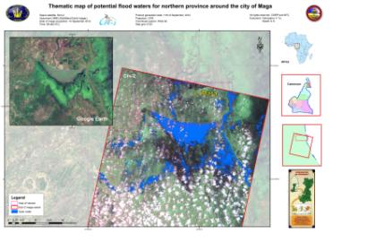
Thematic map of potential flood waters around the city of Maga

The UN-SPIDER Regional Support Office in Ukraine (Space Research Institute NASU-NSAU) supported the relief efforts following the September floods in Cameroon by providing flood maps. In September 2012, the northern part of Cameroon was hit by severe floods. Subsequently, the International Charter “Space and Major Disasters” was activated to acquire satellite images over affected regions. In the context of this activation, the UN-SPIDER Regional Support Office in Ukraine, the State Space Agency of Ukraine (SSAU) and the Center of the Special Information Receiving and Processing and the Navigating Field Control (CSIRP and NFC) coordinated their efforts in order to acquire images from the Ukrainian remote sensing satellite Sich-2 and deliver maps of flood waters. Two images were acquired: One of the city of Maga (10 September 2012) and one of the city of Garoua (15 September 2012).
International Charter
Mon, 1 Oct 2012 - 09:37
Ukraine Regional Support Office

Footer menu

  • Contact
  • Terms of Use

User account menu

  • Log in