• English
  • Español
  • Français

United
Nations


Office for Outer Space Affairs
UN-SPIDER Knowledge Portal

  • Accueil
  • À propos
    • Qu'est-ce que l'ONU-SPIDER?
    • À propos d’UNOOSA
    • Publications
    • Offres d'emploi
    • Rencontrez l'équipe
    • Contact
  • Applications spatiales
    • Technologie satellitaire
    • Mécanismes d’urgence
    • Recovery Mechanisms
    • Réseau international d'alerte aux astéroïdes
    • Space Mission Planning Advisory Group
    • Initiative internationale sur la météorologie spatiale
    • Les technologies spatiales à l'ONU
    • Comptes-rendus d'utilisateurs
  • Liens & ressources
    • Application de données du mois
      • Disaster Recovery
    • Sources de données
    • SIG et logiciels de télédétection
    • Online Learning Resources
    • Institutions
  • Risques & catastrophes
    • Prévention des risques de catastrophe
    • Systèmes d'alerte précoce
    • Gestion des catastrophes et des interventions d'urgence
    • Aléas naturels
    • Cadre d'action de Sendai
    • L'ONU et la prévention des risques de catastrophe
    • L'ONU et les alertes précoces
    • L'ONU et la gestion des catastrophes
  • Appui technique
    • Missions Conseil
    • Appui d’urgence
    • Appui à distance
    • Pratiques recommandées
    • Activités de formation
    • Utilisations pratiques
  • Réseaux
    • Bureaux régionaux d’appui
    • GP-STAR
    • MHEWS
    • IWG-SEM
  • Projets
    • SPEAR
    • SEWS-D
    • EvIDENz
    • Flood GUIDE
  • Actualités
    • Actualités
    • Événements
    • Événements passés

Breadcrumb

  • Home
  • CATHALAC Analyses Mangrove Cover of Guatemala
  • CATHALAC analyses Mangrove Cover of Guatemala

CATHALAC analyses Mangrove Cover of Guatemala

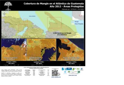
Mangrove Cover on the Atlantic coast in Guatemala

In collaboration with the Ministry of Environment & Natural Resources (MARN) in Guatemala, UN-SPIDER's Regional Support Office CATHALAC (Water Center for the Humid Tropics of Latin America and the Caribbean) is carrying out a satellite-based analysis of the current mangrove cover of Guatemala. The experts elaborated several maps showing the cover in 2012. Various remote sensing and field data techniques were applied to conduct this research. The experts used satellite images of the periods from 2001 to 2012 including Landsat-5 TM, Landsat-7 ETM + (NASA / USGS), Hyperion (NASA) and ALOS PALSAR (JAXA).

Mangrove forests are a natural protective barrier against tropical storms and hurricanes. This research was conducted of the necessity to quantify and identify the current areas of mangroves on the Pacific as well as the Atlantic coast of Guatemala. The results show that both the Pacific and Atlantic Mangrove forests cover an area of approximately 18.904 hectares (189.04 square kilometers), of these only 27.07% (5117.73 hectares) are regulated and protected by the Protected Areas Act of Guatemala.

The full technical report on this analysis is available online in Spanish language (2.78 MB).
SERVIR (Spanish)
Mon, 8 Oct 2012 - 08:32
Guatemala
Water Center for the Humid Tropics of Latin America and the Caribbean (CATHALAC)

Footer menu

  • Contact
  • Terms of Use

User account menu

  • Log in