• English
  • Español
  • Français

United
Nations


Office for Outer Space Affairs
UN-SPIDER Knowledge Portal

  • Accueil
  • À propos
    • Qu'est-ce que l'ONU-SPIDER?
    • À propos d’UNOOSA
    • Publications
    • Offres d'emploi
    • Rencontrez l'équipe
    • Contact
  • Applications spatiales
    • Technologie satellitaire
    • Mécanismes d’urgence
    • Recovery Mechanisms
    • Réseau international d'alerte aux astéroïdes
    • Space Mission Planning Advisory Group
    • Initiative internationale sur la météorologie spatiale
    • Les technologies spatiales à l'ONU
    • Comptes-rendus d'utilisateurs
  • Liens & ressources
    • Application de données du mois
      • Disaster Recovery
    • Sources de données
    • SIG et logiciels de télédétection
    • Online Learning Resources
    • Institutions
  • Risques & catastrophes
    • Prévention des risques de catastrophe
    • Systèmes d'alerte précoce
    • Gestion des catastrophes et des interventions d'urgence
    • Aléas naturels
    • Cadre d'action de Sendai
    • L'ONU et la prévention des risques de catastrophe
    • L'ONU et les alertes précoces
    • L'ONU et la gestion des catastrophes
  • Appui technique
    • Missions Conseil
    • Appui d’urgence
    • Appui à distance
    • Pratiques recommandées
    • Activités de formation
    • Utilisations pratiques
  • Réseaux
    • Bureaux régionaux d’appui
    • GP-STAR
    • MHEWS
    • IWG-SEM
  • Projets
    • SPEAR
    • SEWS-D
    • EvIDENz
    • Flood GUIDE
  • Actualités
    • Actualités
    • Événements
    • Événements passés

Breadcrumb

  • Home
  • Envisat Data Processed For The Most Accurate Biomass Map of The Northern Hemisphere
  • Envisat data processed for the most accurate biomass map of the Northern Hemisphere

Envisat data processed for the most accurate biomass map of the Northern Hemisphere

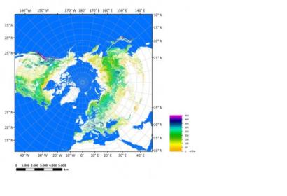
The European Space Agency’s (ESA) Envisat satellite helps scanning the NorthSatellite Envisat helps creating the most accurate Northern biomass map to date which will improve the knowledge on the carbon cycle and will help to predict the future of Earth’s climate.

Thanks to the European Space Agency’s (ESA) Envisat satellite, scientists have developed a new biomass map of the Northern Hemisphere with the best resolution to date, with 1 pixel for each kilometer on the ground. Envisat was an Earth observation satellite launched in 2002 with two key instruments: the Medium Resolution Imaging Spectrometer (MERIS) and the Advanced Synthetic Aperture Radar (ASAR) with the mission of collecting various data as well as taking radar images. To build up this new biomass map scientists compiled more than 70.000 radar images dated from October 2009 to February 2011. “Combining a large number of radar data sets" said Maurizio Santoro from Gamma Remote Sensing in an article on the ESA website "yields a greater sensitivity and gives more accurate information on what’s below the forest canopy." The map covers the entire biomass of forests in the Northern Hemisphere, which provide spectacular carbon stores. Better maps on biomass measurements will help scientists to improve their understanding of the carbon cycle and even predict the future of Earth’s climate.
earthzine
Fri, 19 Jul 2013 - 12:13

Footer menu

  • Contact
  • Terms of Use

User account menu

  • Log in