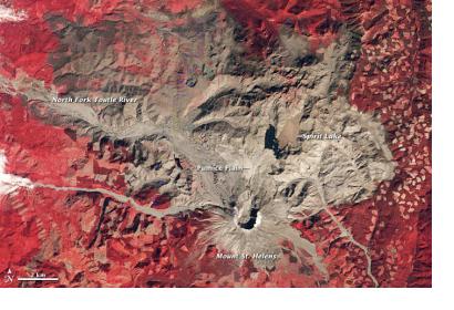
In 1980 Mount St. Helens erupted causing a cataclysmic flank collapse, avalanche, and explosion on May 18. Continental USA experienced its first major eruption during the era of modern scientific observation and the largest landslide in recorded history. The eruption caused tremendous destruction.
With the help of NASA Landsat satellite imagery, scientists tracked the recovery of Mt. St. Helens over the last three decades. NASA elaborates: "In the three decades since the eruption, Mt. St. Helens has given scientists an unprecedented opportunity to witness the intricate steps through which life reclaims a devastated landscape. The scale of the eruption and the beginning of reclamation in the Mt. St. Helens blast zone are documented in this series of images captured by NASA’s Landsat series of satellites between 1979 and 2011. The older images are false-color (vegetation is red) because earlier Landsats could not “see” blue light. To make a photo-like satellite image, you need red, green, and blue wavelengths of light."
On their website, NASA offers a slide show of the scene over Mt. St. Helens to visualize the changes between 1979 and 2013. It is also possible to download a KML file for Google Earth.

