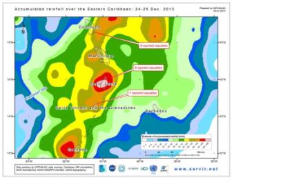
Between December 24 and 25, 2013, the eastern Caribbean islands of Dominica, Saint Lucia and Saint Vincent and the Grenadines were affected by torrential rains which triggered massive flooding and local landslides. The Associated Press reported that on the three islands, there were some 20 casualties. The Prime Ministers of those countries declared the state of national disaster, and even the head of the Organization of American States gave a statement on the tragedy.
In response to requests coming from the affected countries, and in the context of CATHALAC's role as a UN-SPIDER Regional Support Office in the region, CATHALAC's Division of Applied Research and Development prepared an analysis of the events triggering the disaster. The analysis was based on satellite-derived estimates of rainfall, principally from NOAA's Satellite and Information Service (NESDIS), and climatology data from the WorldClim 1.4 database. The results of the analysis showed that a substantial quantity of rain fell over the eastern Caribbean in the 2-day period.
Where, for instance, on an average 2-day period in December (based on the climatology), Dominica receives some 13.2 mm of rainfall, on 24 to 25 December 2013, satellites recorded an average of 54.7 mm across the entire island (in other words, 314% more rainfall than what is considered normal). In the case of Saint Lucia, average rainfall over any given 2-day period in December is 9.3 mm but on 24 to 25 December 2013, some 179.9 mm fell (a whopping 1839% above normal). And in Saint Vincent and the Grenadines, the average rainfall for any given two days in December is 10.9mm, but on 24 to 25 December 2013, 120.5 mm fell (1009% above normal).
CATHALAC's analyses are available on Facebook, and were shared with representatives of the disaster management agencies of the three affected countries, as well as the University of the West Indies (another UN-SPIDER Regional Support Office), and the Caribbean Community (CARICOM)'s Caribbean Public Health Agency (CARPHA).

