• English
  • Español
  • Français

United
Nations


Office for Outer Space Affairs
UN-SPIDER Knowledge Portal

  • Accueil
  • À propos
    • Qu'est-ce que l'ONU-SPIDER?
    • À propos d’UNOOSA
    • Publications
    • Offres d'emploi
    • Rencontrez l'équipe
    • Contact
  • Applications spatiales
    • Technologie satellitaire
    • Mécanismes d’urgence
    • Recovery Mechanisms
    • Réseau international d'alerte aux astéroïdes
    • Space Mission Planning Advisory Group
    • Initiative internationale sur la météorologie spatiale
    • Les technologies spatiales à l'ONU
    • Comptes-rendus d'utilisateurs
  • Liens & ressources
    • Application de données du mois
      • Disaster Recovery
    • Sources de données
    • SIG et logiciels de télédétection
    • Online Learning Resources
    • Institutions
  • Risques & catastrophes
    • Prévention des risques de catastrophe
    • Systèmes d'alerte précoce
    • Gestion des catastrophes et des interventions d'urgence
    • Aléas naturels
    • Cadre d'action de Sendai
    • L'ONU et la prévention des risques de catastrophe
    • L'ONU et les alertes précoces
    • L'ONU et la gestion des catastrophes
  • Appui technique
    • Missions Conseil
    • Appui d’urgence
    • Appui à distance
    • Pratiques recommandées
    • Activités de formation
    • Utilisations pratiques
  • Réseaux
    • Bureaux régionaux d’appui
    • GP-STAR
    • MHEWS
    • IWG-SEM
  • Projets
    • SPEAR
    • SEWS-D
    • EvIDENz
    • Flood GUIDE
  • Actualités
    • Actualités
    • Événements
    • Événements passés

Breadcrumb

  • Home
  • Mapping Global Forests In Unprecedented Detail
  • Mapping global forests in unprecedented detail

Mapping global forests in unprecedented detail

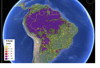
Forest cover in South America viewed on the Geo-Wiki platform (Image: IIASA/Geo-Wiki/Google Earth)Forest cover in South America viewed on the Geo-Wiki platform (Image: IIASA/Geo-Wiki/Google Earth)

The International Institute for Applied Systems Analysis (IIASA) Geo-Wiki team have produced new global forest maps combining citizen science with different data sources.

"The new maps rely on a combination of recent multisensory remote sensing data, statistics and crowdsourcing," said Dmitry Schepaschenko, the lead author of the study. "By combining different data sources, and incorporating the input of trained citizen scientists, we were able to produce new maps that are more accurate than any existing data source."

IIASA further explains the method of the mapping process: "The study introduces two global forest maps, both at one-kilometer resolution, which provide a good compromise between the level of detail and global coverage. The first, which the researchers call the “best-guess” map, uses eight different data sources and relied on a network of citizen scientists to check or validate the classification of land cover, by looking at high-resolution satellite imagery of different locations. Compared to existing data products, the researchers found, the new hybrid map was more accurate both for forest location and estimation of percentage forest cover."

The maps were published in the journal Remote Sensing of the Environment and are freely available for download on the Geo-Wiki website.
IIASA
Tue, 7 Apr 2015 - 07:47

Footer menu

  • Contact
  • Terms of Use

User account menu

  • Log in