![]()
United
Nations
Efflorescences algales nuisibles
, processed by ESA, CC BY-SA 3.0 IGO.")
Definition
Facts and figures
Further information
UN-SPIDER Regional Support Offices with hazard-specific expertise
Related content on the Knowledge Portal
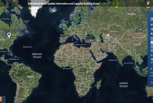 The World Water Quality Information and Capacity Building Portal (IIWQ) is a webmap that illustrates data on turbidity, chlorophyll-a, total absorption as well as the EOMAP specific harmful algal bloom indicator (HAB indicator). Where access to in-situ data is available station values are presented.Publishing institution:
-
The World Water Quality Information and Capacity Building Portal (IIWQ) is a webmap that illustrates data on turbidity, chlorophyll-a, total absorption as well as the EOMAP specific harmful algal bloom indicator (HAB indicator). Where access to in-situ data is available station values are presented.Publishing institution:
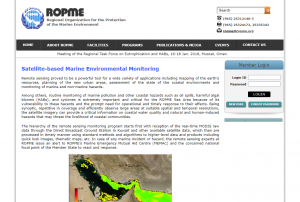 The ROPME has initiated a regional program and special remote sensing unit for routine monitoring of marine and coastal environments in its regional marine area (the Gulf, Sea of Oman and Arabian Sea), which is conventionally, known as ROPME Sea Area.
This program relies essentially on processing and utilization of real-time and near-real time satellite data from NASA’s MODIS sensor that is being received through the MODIS Direct Broadcast Receiving Station. This station has been installed at ROPME Secretariat in Al-Jabriya, Kuwait in early 2003 and still operative since that data. The station is being operated and managed by the experts of the Remote Sensing Unit (RSU) and routinely receives satellite data only from MODIS sensor onboard Terra and Aqua satellites.
The RSU also provides a guidance and advice to the national focal points and other concerned authorities in case they need further information on status of the marine environment in their…Publishing institution: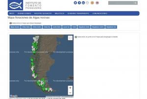 Set of maps developed by the Harmful Algal Studies Center (CREAN) of the Fisheries Development Institute (IFOP), whose purpose is to show the relative abundance of the Alexandrium catenella microalga, with the aim of informing and alerting about the presence of this dinoflagellate harmful. This information is preventive and in no case determines the opening and closing of seafood extraction areas.Publishing institution:
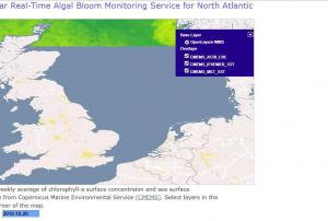 The map indicates chlorophyll-A and sea surface temperatures in the North Atlantic based on data.
The products can be downloaded from the CMEMS catalogue using different protocol (ftp, wms...):
NEAR REAL TIME (DAILY UPDATED) BASED ON SINGLE SENSOR (OLCI-A) AND MERGED SENSORS (MODIS-A & VIIRS-N):
Global level-3 Daily: OCEANCOLOUR_GLO_CHL_L3_NRT_OBSERVATIONS_009_032
Global level-4 Climatology, Monthly, 8-days products and daily-Optimal-Interpolation: OCEANCOLOUR_GLO_CHL_L4_NRT_OBSERVATIONS_009_033
Atlantic level-4 Daily-Optimal-Interpolation: OCEANCOLOUR_ATL_CHL_L4_NRT_OBSERVATIONS_009_037
REPROCESSED TIME-SERIES BASED ON MERGED SENSORS (SeaWifs, MERIS, MODIS-A & VIIRS-N):
Global level-3 Daily products: OCEANCOLOUR_GLO_CHL_L3_REP_OBSERVATIONS_009_085
Global level-4 Monthly, 8-days and Daily-Optimal-Interpolation: OCEANCOLOUR_GLO_CHL_L4_REP_OBSERVATIONS_009_082
Atlantic level-4 Daily-Optimal-Interpolation:…Publishing institution: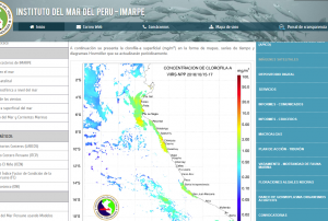 La productividad del mar peruano es muy sensible a los efectos de El Niño-Oscilación del Sur. Se conoce que en años neutros y fríos (La Niña), la concentración superficial de clorofila-a (indicador de la biomasa del fitoplancton) en las aguas sobre el margen continental, varía entre 1.2 y 6.7 mg/m3, mientras que en años cálidos (El Niño) este rango tiende a reducirse a 1.2 - 2.6 mg/m3.
Por ello, en IMARPE, complementariamente, se monitorea la clorofila-a superficial con la información que provee el sensor MODIS (Moderate Resolution Imaging Spectroradiometer, en inglés) con una resolución temporal diaria y espacial de 4 km.Publishing institution: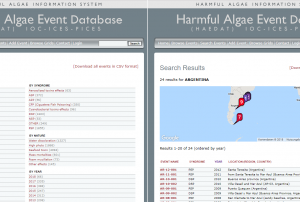 The Harmful Algal Information System, HAIS, will when fully established consist of access to information on harmful algal events, harmful algae monitoring and management systems worldwide, current use of taxonomic names of harmful algae, and information on biogeography of harmful algal species. Supplementary components are an expert directory and a bibliography.
The HAIS System is being built within the "International Oceanographic Data and Information Exchange" (IODE) of the "Intergovernmental Oceanographic Commission" (IOC) of UNESCO, and in cooperation with WoRMS, ICES, PICES, IAEA and ISSHA.
HAEDAT Disclaimer: The HAEDAT database contains information based on yearly national reports by ICES and PICES member states. The available information on individual events varies greatly from event to event or country to country. Monitoring intensity, number of monitoring stations, number of samplings, stations, etc. also…Publishing institution: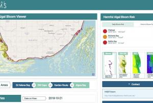 Webmap of Algal bloom detections, CHl-A from MODIS nFLH, Sea Surface Temperature (Odyssea), Chlorophyll-A from Sentinel OLCI.
The HAB Decision Support Tool (DeST) provides a capability for monitoring and assessing risk of HAB events for the South African coastal area to approximately 50km offshore. Risk assessment and monitoring is based on quantified understanding of bloom dynamics (Pitcher & Nelson, 2006), hypoxic impacts (Pitcher et al 2014), and earth observation monitoring capabilities (Bernard et al 2006). Maps of various ocean colour-derived phytoplankton biomass proxies, sea surface temperature, and ocean state (wind, current, sea state) are used to provide information on the presence and movement of blooms, and extracted time series of these data provide a "virtual buoy" capability giving a multi-parameter risk index.Publishing institution: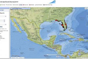 HABSOS combines in-situ measurements, with oceanographic and meteorological data. When clicking on metadata in the website the 15+ integrated data sources can be viewed.Publishing institution:
Term Parents
UN-SPIDER Regional Support Offices with hazard-specific expertise
![]()