• English
  • Español
  • Français

United
Nations


Office for Outer Space Affairs
UN-SPIDER Knowledge Portal

  • Accueil
  • À propos
    • Qu'est-ce que l'ONU-SPIDER?
    • À propos d’UNOOSA
    • Publications
    • Offres d'emploi
    • Rencontrez l'équipe
    • Contact
  • Applications spatiales
    • Technologie satellitaire
    • Mécanismes d’urgence
    • Recovery Mechanisms
    • Réseau international d'alerte aux astéroïdes
    • Space Mission Planning Advisory Group
    • Initiative internationale sur la météorologie spatiale
    • Les technologies spatiales à l'ONU
    • Comptes-rendus d'utilisateurs
  • Liens & ressources
    • Application de données du mois
      • Disaster Recovery
    • Sources de données
    • SIG et logiciels de télédétection
    • Online Learning Resources
    • Institutions
  • Risques & catastrophes
    • Prévention des risques de catastrophe
    • Systèmes d'alerte précoce
    • Gestion des catastrophes et des interventions d'urgence
    • Aléas naturels
    • Cadre d'action de Sendai
    • L'ONU et la prévention des risques de catastrophe
    • L'ONU et les alertes précoces
    • L'ONU et la gestion des catastrophes
  • Appui technique
    • Missions Conseil
    • Appui d’urgence
    • Appui à distance
    • Pratiques recommandées
    • Activités de formation
    • Utilisations pratiques
  • Réseaux
    • Bureaux régionaux d’appui
    • GP-STAR
    • MHEWS
    • IWG-SEM
  • Projets
    • SPEAR
    • SEWS-D
    • EvIDENz
    • Flood GUIDE
  • Actualités
    • Actualités
    • Événements
    • Événements passés

Breadcrumb

  • Home
  • Quality of Inland And Coastal Waters To Be Monitored Using Satellite Data
  • Quality of inland and coastal waters to be monitored using satellite data

Quality of inland and coastal waters to be monitored using satellite data

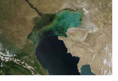
Global coverage satellites to monitor the quality of inland and coastal waters through the new EOMAP service (Image: NASA)Global coverage satellites to monitor the quality of inland and coastal waters through the new EOMAP service (Image: NASA)

The first harmonized and high-resolution monitoring service for inland and coastal waters has been launched providing water quality information directly accessible online through the eoApp web application.

This new service is offered by the provider of aquatic remote sensing solutions EOMAP GmbH & Co. KG, which is easing, among others, the identification of long-term trends and the understanding of emerging problems in near real time over large areas containing numerous water bodies.

Turbidity, chlorophyll concentrations and organic/inorganic components are some of the water quality parameters that can be generated for any location worldwide and presented in digital map form. The satellites used are already operating with global coverage allowing the new EOMAP service to implement the inland water quality monitoring for the whole globe, covering from local to continental scales.  

"Our remote sensing-based service sets the new standard for monitoring inland water systems, of almost any size, in their entirety, regardless of geo-political boundaries  - at very competitive rates - with sampling frequencies of daily to weekly and at spatial resolutions of 2 m, 30 m and 500m", explained Karin Schenk, head of EOMAP Water Quality Services, who also recently spoke at the United Nations/Germany International Conference on Earth Observation, hosted by the UN-SPIDER Bonn office.
Sensors&Systems
Tue, 9 Jun 2015 - 11:22
Global

Footer menu

  • Contact
  • Terms of Use

User account menu

  • Log in