• English
  • Español
  • Français

United
Nations


Office for Outer Space Affairs
UN-SPIDER Knowledge Portal

  • Accueil
  • À propos
    • Qu'est-ce que l'ONU-SPIDER?
    • À propos d’UNOOSA
    • Publications
    • Offres d'emploi
    • Rencontrez l'équipe
    • Contact
  • Applications spatiales
    • Technologie satellitaire
    • Mécanismes d’urgence
    • Recovery Mechanisms
    • Réseau international d'alerte aux astéroïdes
    • Space Mission Planning Advisory Group
    • Initiative internationale sur la météorologie spatiale
    • Les technologies spatiales à l'ONU
    • Comptes-rendus d'utilisateurs
  • Liens & ressources
    • Application de données du mois
      • Disaster Recovery
    • Sources de données
    • SIG et logiciels de télédétection
    • Online Learning Resources
    • Institutions
  • Risques & catastrophes
    • Prévention des risques de catastrophe
    • Systèmes d'alerte précoce
    • Gestion des catastrophes et des interventions d'urgence
    • Aléas naturels
    • Cadre d'action de Sendai
    • L'ONU et la prévention des risques de catastrophe
    • L'ONU et les alertes précoces
    • L'ONU et la gestion des catastrophes
  • Appui technique
    • Missions Conseil
    • Appui d’urgence
    • Appui à distance
    • Pratiques recommandées
    • Activités de formation
    • Utilisations pratiques
  • Réseaux
    • Bureaux régionaux d’appui
    • GP-STAR
    • MHEWS
    • IWG-SEM
  • Projets
    • SPEAR
    • SEWS-D
    • EvIDENz
    • Flood GUIDE
  • Actualités
    • Actualités
    • Événements
    • Événements passés

Breadcrumb

  • Home
  • Satellite Technology Improves Tracking of Hurricane Wind Speed
  • Satellite technology improves tracking of hurricane wind speed

Satellite technology improves tracking of hurricane wind speed

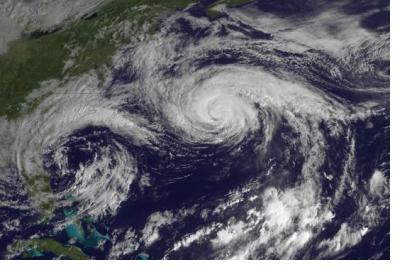
Image of Hurricane Joaquin over the Atlantic Ocean north of Bermuda taken by GOES East on October 5, 2015.Image of Hurricane Joaquin over the Atlantic Ocean north of Bermuda taken by GOES East on October 5, 2015.

A new satellite remote sensing technique has been proven effective in measuring ocean wind speed in order to better track hurricanes and cyclones. This technique uses GPS technology to send signals to Earth’s surface and gather data via Global Navigation Satellite Systems-Reflectometry (GNSS-R) and is expected to lead to better forecasts in the future.

For this study, a GNSS-R instrument was attached to the UK TechDemoSat-1 (TDS-1) satellite and collected data between May 2015 and October 2016, during which Hurricanes Joaquin and Jimena, and Typhoon Chad-hom took place. The observations collected successfully showed changes in ocean surface conditions consistent with cyclone and hurricane wind fields. Even more promisingly, the GNSS-R was able to track speeds in and around the eye of a cyclone, something that previously proved to be difficult through other tracking methods.

This technique is not unfamiliar to scientists, as it has proved effective in the past when used by aircrafts for wind speed tracking. The ability to gather this data from satellites, however, will allow for more far-reaching information to be available for research.

Researchers Giuseppe Foti, Christine Gommenginger, and Meric Srokosz from the National Oceanography Centre in Southampton, United Kingdom, authored the study, which was funded by the European Space Agency and NREC National Capability at the National Oceanography Centre.
Measuring Hurricane Wind Speed from Space
Thu, 8 Mar 2018 - 11:11

Footer menu

  • Contact
  • Terms of Use

User account menu

  • Log in