The Sendai Framework for Disaster Risk Reduction (SFDRR) recognises the usefulness of tracking losses triggered by natural hazards over time to assess the effects that disaster risk reduction efforts put in place are having over time. The Technical Guidance for Monitoring and Reporting on Progress in Achieving the Global Targets of the Sendai Framework for Disaster Risk Reduction provided information on indicators to be used to track such losses.
Losses and impacts in the agricultural sector are considered in this Technical Guidance and include direct losses to crops and impacts in terms of the number of people who are affected by natural hazards, who are also directly engaged in agricultural activities. Economic losses have a direct impact on the gross domestic product of any country and the Technical Guidance makes reference to the assessment of agricultural crop monetary loss through indicator C2C:
C2C = Loss in annual crop stocks +
Loss in perennial crop stock +
Annual crop production loss +
Perennial crop production loss +
Crop assets loss
How can Earth observation contribute?
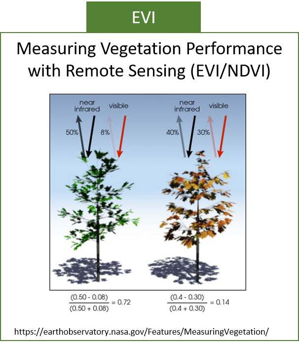
Earth observation tools can be used to track the geographical extent of droughts on annual and perennial crops using indicators such as the Normalized Difference Vegetation Index (NDVI) or the Enhanced Vegetation Index (EVI). The NDVI is extracted from typical optical satellite imagery that includes red and near infrared bands. The EVI is extracted from optical satellite imagery that my also include the blue band in addition to the red and near infrared bands. The incorporation of the use of the blue band helps manage the effects of atmospheric dust, aerosols, ground reflection below vegetation and chlorophyll saturation.
Both the NDVI and the EVI assess the effects of droughts on crops comparing the ratio of the amount of reflected light in the red and the near infrared bands of the spectrum.
To make use of these indicators to assess crop losses, ground calibrations are required for all the various types of crops to be estimated, so that the numeric values of the NDVI or the EVI are linked with the degree of specific crop losses.
The EvIDENz-suggested approach
The EvIDENz procedure goes one step further in the use of such vegetation indices to improve the assessment of the effects of droughts on crops. The EvIDENz procedure incorporates the use of a comparative drought index, meaning it compares the intensity of droughts on crops in a specific year with the intensity of droughts in a long time series such as the Moderate Resolution Imaging Spectroradiometer (MODIS) vegetation data products starting in the middle of the year 2000.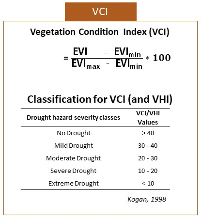 The EvIDENz procedure makes use of the Vegetation Condition Index (VCI) developed by Kogan in 1998 that compares the specific value of the EVI in a specific year with values of the EVI for all other years between 2001 and the present.
As in the case of the use of the NDVI or the EVI, the use of the VCI requires calibration with in situ data on crop losses on an annual basis.
In the absence of data on crop losses over the years, Kogan developed a classification of drought severity using the value of the VCI for each region of a country or province.
In the EvIDENz procedure the assumption is made that there will be total crop loss when there is an extreme drought (VCI values less than 10 units). In addition, the assumption is made that crops are damaged but not destroyed when the values of the VCI range between 10 and 40 units.
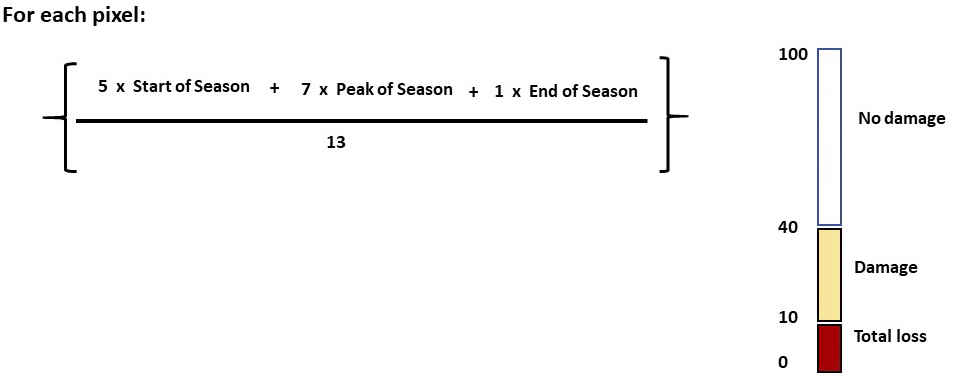
A further refinement suggested by the EvIDENz project is to incorporate - for each type of crop - information on its phenology and the period of time when the drought manifested itself with respect to the phenology.
It is well known that a drought has less effects on crop yield if the drought manifests itself towards the end of the crop season, and it has major impacts during the start or the peak of the season.
The EvIDENz procedure suggests a holistic approach to the calculation of the classification of the drought index on the basis of a linear combination of the values of the EVI and the temporal manifestation of the drought related to the phenology of specific crops before the VCI is calculated.
 The linear combination proposed in the EvIDENz procedure is:
Assign a relative value of 5 units if the drought takes place at the start of the season
Assign a relative value of 7 units if the drought takes place during the peak of the season
Assign a value of 1 unit if the drought takes place at the end of the season
The weighted calculation of the VCI is then conducted as follows for each pixel:
The EviDENz procedure would include the following steps:
Extract the information from the EVI for all years since the middle of 2000, on a 16-day interval
Extract information on the geographical location and extent of each type of crop
Extract information on the yield for each type of crop per hectare and the commercial price of the crop
Extract information on the phenology of each type of crop
Extract the information on the temporal manifestation of the drought and its duration in relation to the type of crop
Estimate the VCI using the weighted linear combination
For each type of crop, use the suggested ranges of the value of the VCI to estimate the impacts of the drought on each type of crop
Combine this information to extract the number of crops damaged or lost, and finally the financial losses
Incorporate this result in the C2C indicator proposed in the SFDRR
Constraints and critical issues to consider when using this procedure:
The procedure should not be used in areas where the use of irrigation is permanent, as the values of the VCI may not adapt well with the degree of damages or losses.
Taking into consideration the fact that the NDVI, the EVI and hence the VCI rely on optical satellite imagery, it is important to assess the extent of cloud cover during the entire crop cycle and over many years so as to be sure that the presence of clouds does not interfere with the calculation of the VCI.
The procedure should be used with care in case there is crop rotation over the years or changes in crops is specific geographic regions, as this will introduce errors into the calculation of the VCI.
The procedure should not be used for agricultural techniques such as intercropping, mixed cropping and stir cropping involving growing two or more crops in proximity due to the large pixels of the MODIS and uncertainties in the crop which occupies a 250m x 250m pixel area.