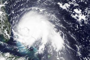
Hurricane Dorian, a category 5 hurricane, made landfall at Elboy Cay, Abaco, Bahamas, on 1 September. The hurricane had devastating effects, especially on the islands of Grand Bahama and Abaco, as they had prolonged exposure to extreme hurricane force winds, storm surges, flooding and intense rainfall.
The Abaco Islands and Grand Bahama, in the north of the archipelago, were battered by the storm for two days which decimated whole areas, leaving houses without roofs, scattered debris and flooding as up to 35 inches of rain fell.
Dorian is the strongest hurricane on record to make landfall in Bahamas and caused massive storm surges and flooding of entire villages, destroyed thousands of homes, downed power and telecommunication lines, put health facilities out of action, made roads impassable and contaminated the drinking water system with salt water.
Both the International Charter Space and Major Disaster and the Copernicus Emergency Management Service - Mapping have been activated for the event.
Links to resources
| Publisher | Title | URL |
|---|---|---|
| International Charter Space and Major Disasters | Hurricane Dorian in Bahamas activation page | https://disasterscharter.org/web/guest/activations/-/article/storm-hurricane-urban-in-bahamas-activation-620- |
| Copernicus Emergency Management Service - Mapping | Tropical Cyclone Dorian in Bahamas activation page | https://emergency.copernicus.eu/mapping/list-of-components/EMSR385 |
| Maxar | Hurriance Dorian activation page | http://www.digitalglobe.com/ecosystem/open-data/hurricane-dorian |
| UN OCHA | Hurricane Dorian overview page | https://reliefweb.int/disaster/tc-2019-000095-dom |
| NASA Disaster Programme | Mapping damage to the Bahamas | https://disasters.nasa.gov/hurricane-dorian-2019/mapping-dorian%E2%80%99s-damage-bahamas |
