")
Access to geospatial data from a wide range of institutions is key to successful disaster risk management and emergency response efforts. In the early phases of disaster risk management, combining data sets on issues such as population density, land use, economic activity and frequency of different natural hazards in an area helps develop an understanding of the risk at hand. During emergency response, entities involved must have quick access to reliable data generated by other institutions in formats that are compatible so that they can be swiftly and easily combined to generate the information required to mitigate and respond to emerging demands triggered by the disasters. Quite often, however, data is not readily shared by institutions, nor is it produced in compatible formats and following the same metadata standards. This limits the ability of civil protection agencies and other stakeholders to leverage geospatial data for disaster management.
Spatial Data Infrastructures (SDI) aim to address obstacles to cooperation and facilitate the discovery, access to, sharing and interoperability of spatial information across institutions, usually in a country or region. An SDI, or National Spatial Data Infrastructure (NSDI), usually consists of a set of technologies and tools, such as geoportals and web services, but also of policies and institutional arrangements that serve as the basis to facilitate the discovery of data generated by various institutions, as well as its distribution, exchange, and more frequent re-use. "SDIs allow the publication, visualization, and analysis of geographic data at low cost and in an interoperable way, they constitute a new paradigm that is revolutionizing the world of Geographic Information Technologies (GIT) and that offers new possibilities that need to be explored and exploited" (Santamaría, 2019).
In the last two decades, governments, international and regional organizations, non-governmental organizations and companies at the local, regional, national, and international levels have been implementing SDIs. Governments and organizations justify the establishment of SDIs as strategic structures to contribute to achieving goals such as land-use planning, a more rational management of natural resources, planning for sustainable development, certainty about land ownership, combating poverty, etc.
Objectives of SDIs
SDIs represent a solution to a common problem faced by various state institutions, as well as regional and international organizations - the difficulty of using data sources outside of their competence because such data is not always available, is in incompatible formats, and no data sharing policiesare in place. The basic objectives of SDIs include:
- To promote and to facilitate universal access, use, and exchange of spatial information in support of planning
- To create an environment that facilitates coordination and cooperation among all stakeholders to reach agreements
- To eliminate duplication in capturing spatial information
- To facilitate the capture of spatial information through cooperation among state agencies
- To promote the effective management and maintenance of spatial information
- To facilitate the protection of the state copyright in works related to spatial information
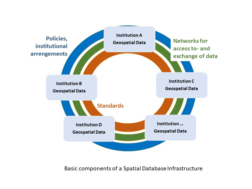
Basic components of an SDI
To establish an SDI, four components must be integrated:
- Institutional and national policies
- Data access and distribution platforms (geoportals & geoviewer)
- Standards
- Geospatial data
Policies serve to establish a legal basis, ideally at the national level, and eliminate institutional restrictions that inhibit access to data generated by multiple institutions, allocation of resources and the formulation of guidelines to establish SDIs. Geoportals, data-sharing platforms and web services for geographic datafacilitate data access and exchange among the institutions that comprise the SDI, and data standards ensure compatibility of the data generated by various institutions.
Examples of use of SDIs in risk assessment
Assessing the risks associated with natural hazards requires the combination of data on the hazard, the exposure of vulnerable elements and their type or class and level or degree of vulnerability. These data are generated by institutions such as natural hazard observatories and research centers, the ministries of environment, agriculture, health, education, public works and communications, national geographic institutes and national statistical institutes.
For example, the analysis of landslide hazard requires information on:
- Geology and lithology that is generated by observatories that monitor natural hazards, national geological services, or research centers
- The slope and its orientation, which can normally be generated with the cartographic information generated by the national geographic institutes
- Land cover, which is generally generated by the environment ministries in the case of forests and the agriculture ministries in the case of crops
In a complementary fashion, the national statistical institutes generate information on the type of population that is settled in geographical areas exposed to such landslides, their distribution by age ranges, their level of education, their level of poverty, their index of unsatisfied basic needs and other ministries generate equally relevant information to characterize vulnerability, including the location of critical infrastructure such as lifelines (communication routes including roads, aqueducts, and power transmission lines), as well as educational centers, health centers, and other types of infrastructure.
An SDI encourages data sharing through appropriate policies and facilitates the combination of all this geospatial data combine through geographic information systems (SIG) in order to prepare risk maps for various regions or territories.
UN and SDIs
In the United Nations context, the United Nations Committee of Experts on Global Geospatial Information Management (UN-GGIM) has established an Integrated Geospatial Information Framework (IGIF) that provides a basis and a guide for developing, integrating, strengthening and maximizing the management of geospatial information and related resources in all countries. This framework defines nine strategic elements for specific orientation when establishing National Spatial Data Infrastructures (NSDIs) and options that Member States of the United Nations should take into consideration when implementing their NSDIs. The objective is to provide guidance to governments to establish integrated geospatial information frameworks at the national level in each country so that a transformational change is enabled, visible, and sustainable. The framework addresses several key elements that are necessary to strengthen the management of geospatial information.
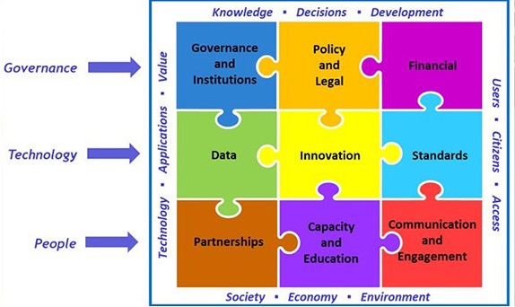
Strategic pathways of the IGIF framework for IDE’s implementation (UNGGIM, 2019)
Each strategic element also includes a series of recommended actions and guiding principles for its implementation, as well as a list of results that countries can expect when completing the tasks. The strategic elements are organized in three main areas of influence:
Governance: Governance is essential to achieve geospatial information integrated into public administration. It includes policies, laws, institutional provisions, regulations, requirements, and financial aspects that must be considered in any sustainable geospatial information program or project.
Technology: Technology influences georeferencing data, innovations, and standards that respond to evolving needs, demands, and uses.
Institutions: This is possibly the most important component, since the institutions, through their employees, enable this framework by implementing all the necessary tasks for a successful SDI, which is often done through partnerships or in collaboration.
Overall, this approach aims to address global challenges related to the use of geospatial information, joint decision-making, and providing directions even in the case of development agendas. This approach makes use of knowledge management to facilitate the formulation of global policies in the field of geospatial information management, production, availability, and use within national, regional, and global policy frameworks.
Case studies
Infrastructure for Spatial Information in the European Community (INSPIRE)
![]() Launched in 2007 by the European Commission, INSPIRE aims at developing a European SDI based on SDIs of Member States. It seeks to enable sharing of and access to relevant, harmonized and reliable geographic information from public sector organizations across Europe. The INSPIRE directive came into force in May 2007 and has been transposed into national law by European Union Member States. Its full implementation is required by 2021. INSPIRE does not require the collection of new data, but seeks to make data collected by European Union Member States available across the continent.
Launched in 2007 by the European Commission, INSPIRE aims at developing a European SDI based on SDIs of Member States. It seeks to enable sharing of and access to relevant, harmonized and reliable geographic information from public sector organizations across Europe. The INSPIRE directive came into force in May 2007 and has been transposed into national law by European Union Member States. Its full implementation is required by 2021. INSPIRE does not require the collection of new data, but seeks to make data collected by European Union Member States available across the continent.
INSPIRE is based one five common principles:
- Data should be collected only once and kept where it can be maintained most effectively.
- It should be possible to combine seamless spatial information from different sources across Europe and share it with many users and applications.
- It should be possible for information collected at one level/scale to be shared with all levels/scales; detailed for thorough investigations, general for strategic purposes.
- Geographic information needed for good governance at all levels should be readily and transparently available.
- Easy to find what geographic information is available, how it can be used to meet a particular need, and under which conditions it can be acquired and used.
To ensure that spatial data and services of Member States are compatible with each other and can be used across boundaries in a consistent way, so-called Implementing Rules (IR) were adopted on metadata, data specifications, network services, data and service sharing, spatial data services, and monitoring and reporting. The IR were adopted in a way that makes them binding for Member States in their entirety.
INSPIRE addresses a total of types of 34 data themes, including natural risk zones, which are defined as “areas where natural hazards are coincident with populated areas and/or areas of particular environmental/cultural or economic value.”
This normative framework is complemented by the INSPIRE Geoportal, a central access point to the data provided by Member States of the European Union and the European Free Trade Association (EFTA).
Colombian Spatial Data Infrastructure - ICDE
Colombian Spatial Data Infrastructure - (ICDE) is an initiative of the Colombian government that has been implemented since 2000 at the national level through the Agustín Codazzi Geographical Institute (IGAC). The ICDE brings together the main producers and users of data to work together on the organization, production, accessibility, availability and publication of geospatial information (ICDE, 2020).
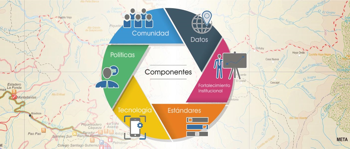
Components of the Colombian Spatial Data Infrastructure - ICDE
By facilitating an exchange among stakeholders, the ICDE allows the collective construction and implementation of policies, standards and other guidelines that facilitate the management of geographic resources, which include data, information and knowledge. The exchange among institutions allows the data to be harmonized to make it available to the government and society to contribute to governance and decision-making, such as in the case of emergencies, disaster prevention and response, among others
The ICDE is includes a Coordination Committee and five Sector Committees that are responsible for overseeing the institutional coordination, and defining, supporting and monitoring the implementation of the strategies. Government agencies engaged in these sectors (environmental, infrastructure, defense and seas, socioeconomic, territorial and borders) include:
- National Statistics Department (DANE)
- National Planning Department (DNP)
- Agustín Codazzi Geographical Institute (IGAC)
- National Disaster Risk Management System (SNGRD)
- Colombian Geological Service
These and many other institutions make up this large system, which facilitates the management of geographic resources in Colombia. For this, the ICDE provides five web-based solutions or geoservices that allow the community to manage geographic knowledge (Table 1).
Service |
Webpage |
|---|---|
| ICDE Portal | http://www.icde.org.co/ |
| National Geographic Portal - PGN | http://pgn.igac.gov.co/ |
| Metadata Catalog | http://metadatos.igac.gov.co/geonetwork/srv/spa/catalog.search#/home |
| Geocontents Web | http://www.icde.org.co/servicios/geocontenidos-web |
| Educational Contents | http://www.icde.org.co/servicios/contenidos-educativos |
Tabla 1. ICDE Geoservices
Importance of the ICDE in the National Information System for Disaster Risk Management
Colombia, like many other countries in the intertropical zone and the Andean region, is located in an area of high exposure to the presence of natural hazards. It is particularly exposed to hydrometeorological events such as El Niño and La Niña.
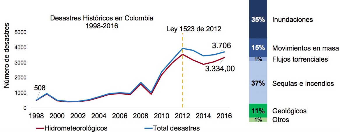
Disasters in Colombia between 1998 – 2016 (DNP, 2018)
A fundamental element in disaster risk management and emergency response is the provision of accurate and updated information on hazards, vulnerabilities, and information on the conditions of the population that lives in a territory. Access to this information facilitates the decision-making process regarding disaster risk management.
A fundamental element in disaster risk management and emergency response is the provision of accurate and updated information on hazards, vulnerabilities, and information on the conditions of the population that lives in a territory. Access to this information facilitates the decision-making process regarding disaster risk management.
The use of the SDI has led to the implementation of free access services based on open information standards and has promoted the development of geographic information systems through the provision of geo-services (WMS, WGS, WFS, etc.) for spatial analysis of the territory that contributes to risk management and emergency response.
Mesoamerican Network for Comprehensive Risk Management (RM-GIR)
The RM-GIR is an initiative framed within the "Mesoamerica Project". It contributes to development, integration, and cooperation among the countries of the Mesoamerican region (Belize, Colombia, Costa Rica, El Salvador, Guatemala, Honduras, Mexico, Nicaragua, Panama, and the Dominican Republic) to expand and improve their capabilities in terms of infrastructure, interconnectivity and social development, including Comprehensive Risk Management (RM-GIR, 2019).
The RM-GIR is a tool for the generation and dissemination of information on comprehensive risk management, to reduce Mesoamerica's vulnerability to disasters caused by natural phenomena.
One of the most relevant achievements of this regional SDI is the coordinated work of the 10 countries in the region, which has resulted in the development of the online platform of the RM-GIR system.
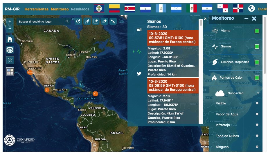
Mesoamerican Network for Comprehensive Risk Management Geoportal (RM-GIR)
The platform currently has more than 1,473 layers of information endorsed by the countries of the region. This almost real-time data is used through geo-services (WMS) to monitor risks and hazards including winds, earthquakes, tropical cyclones, or hot spots related to forest fires. This exchange of information on hazards and disasters strengthens the capacities of institutions related to disaster risk management and civil protection, to make better decisions regarding the impact of natural phenomena. vulnerabilities and risks, as well as climate change.
FOSS applications for developing SDIs
As indicated above, SDIs require the development of regulatory frameworks as well as of technical tools, services and platforms to access data. A number of initiatives aim to help with the latter by providing free and open source (FOSS) software for developing and deploying SDIs.
FOSS in an open software development system based on free and open-source code, which can support entities, agencies, and organizations managing disasters by improving efficiency and the effectiveness of information collection and sharing (Van de Walle, 2014).
In particular, FOSS bases its function on three important criteria:
- Approach: Transparent, open and shared initiative.
- Cost: No acquisition cost and low maintenance cost.
- Adaptability: Quickly adaptable and interoperable.
The implementation of low-cost and easily adaptable FOSS tools in information management systems plays an increasingly important role in the humanitarian sector. This improves the capacity to share information to coordinate disaster response efforts in case of large-scale disasters, in disaster management, mitigation, and preparedness, relief activities, recovery, and reconstruction.
GeoNode
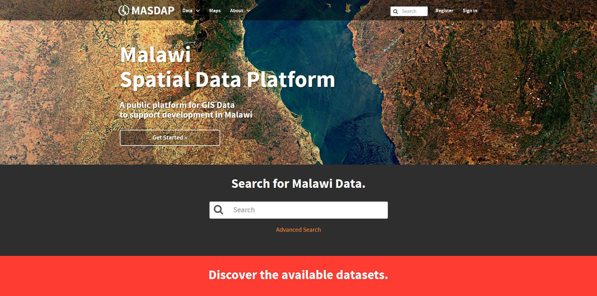
GeoNode is an Open Source, Content Management System (CMS) for geospatial data, which can be used for deploying SDIs. It allows for integrated creation of data, metadata and map visualizations. Its development has been driven by the Global Facility for Disaster Risk Reduction (GFDRR) through its Open Data for Resilience Initiative (OpenDRI), together with OpenGeo (a geospatial company now known as Boundless Geo).
GeoNode can be downloaded from the project page and installed on a local web server or in the cloud. Users can then upload geospatial data as data layers. Via the interface, users can then interact with the layers through their browser.
Examples of the use of GeoNode:
- Malawi Spatial Data Platform
- GeoSINAGER (Bolivia)
- Intergovernmental Authority on Drought and Development (IGAD)
Geoserver
GeoServer is a free and open source web server software that allows publishing maps and data from a variety of formats to access in web browsers and desktop GIS programs such as QGIS. OpenLayers, a free mapping library, is integrated into GeoServer, and makes creating webmaps easy. Data can be shared in compliance with common standards such as the Web Feature Service (WFS).
GeoServer can be downloaded from the project page, which also features documentation resources.
MapServer
MapServer is an Open Source platform for publishing spatial data and interactive mapping applications to the web. Originally developed in the mid-1990’s at the University of Minnesota, MapServer is released under an MIT-style license, and runs on all major platforms. MapServer is not a full-featured GIS system, nor does it aspire to be. It allows to easily publish spatial data and provides some advanced cartography features. The software suite also implements common standards for easy access to data.
Examples of the use of MapServer:
- Interactive map of the city of Buenos Aires, Argentina
- Quebec floodable areas and historic flood maps
Mapender
Mapbender is a content management system for geospatial data services and map applications. It can be used to publish, register, view, navigate, monitor and grant secure access to spatial data infrastructure services. With Mapbender, applications can be set up and configured directly from the browser. Based on state-of-the-art technologies, Mapbender is a flexible client for OGC services.
Example of the use of Mapbender:
Further information about these and other solutions are available on website of the Open Source Geospatial Foundation (OSGeo). OSGeo is a not-for-profit organization whose mission is to “foster global adoption of open geospatial technology by being an inclusive software foundation devoted to an open philosophy and participatory community driven development.” The foundation’s projects, which include the three software suites above, are all freely available and useable under an Open Source Initiative certified open source license. They can be tried out using the OSGeoLive virtual machine (based on Lubuntu), which can be downloaded for free.