The training date is in the past. However, videos and resources of the training can be accessed here.
Structures such as buildings, roads, and other infrastructure absorb and re-emit the sun’s heat more than natural landscapes such as forests and water bodies. Urban areas, where these structures are highly concentrated and greenery is limited, become “islands” of higher temperatures relative to outlying areas. These pockets of heat are referred to as “heat islands.” The rapid growth of urban populations, the urban heat island effect, and increase in the frequency and duration of heat waves due to climate change, raise a series of issues about the increased health risks of sensitive urban populations to extreme heat and the effective means of mitigating the impacts of heat waves.
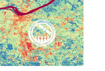
Remote sensing provides global, timely, objective observations to monitor the effects of urban heat islands (UHI) over time. Thermal mapping from satellites can be used to monitor land surface temperature (LST), while optical data collected from satellites can inform where and when land use and land cover have changed over time and can be used to approximate air temperatures. Once UHIs have been mapped, incorporating socioeconomic data pertaining to population, demographics, and health information into heat vulnerability indices (HVI) can help guide interventions to manage heat related risks to public health. This three-part, advanced webinar will build on ARSET’s urban heat island training held in November 2020 with hands-on exercises for participants to measure UHI and construct HVIs for their areas of interest.
This webinar series is a collaboration between NASA’s Applied Remote Sensing Training Program (ARSET) and the National Integrated Heat Health Information System (NIHHIS).
By the end of this training, participants will be able to:
Define what an urban heat island is and why it matters to urban planners and public health experts
Map land surface temperature from Landsat 4, 5, 7, 8, & 9 using Google Earth Engine and source complementary urban heat measurements
Engage with local decision-makers to identify the socioeconomic inputs appropriate for constructing heat vulnerability indices
Apply common techniques used to create heat vulnerability maps for an urban area of interest
Community, municipal, city, state, federal, and private institutions involved in urban planning, health care, energy supply and demand management, and climate mitigation.