  • English
  • Español
  • Français

United
Nations


Office for Outer Space Affairs
UN-SPIDER Knowledge Portal

  • Accueil
  • À propos
    • Qu'est-ce que l'ONU-SPIDER?
    • À propos d’UNOOSA
    • Publications
    • Offres d'emploi
    • Rencontrez l'équipe
    • Contact
  • Applications spatiales
    • Technologie satellitaire
    • Mécanismes d’urgence
    • Recovery Mechanisms
    • Réseau international d'alerte aux astéroïdes
    • Space Mission Planning Advisory Group
    • Initiative internationale sur la météorologie spatiale
    • Les technologies spatiales à l'ONU
    • Comptes-rendus d'utilisateurs
  • Liens & ressources
    • Application de données du mois
      • Disaster Recovery
    • Sources de données
    • SIG et logiciels de télédétection
    • Online Learning Resources
    • Institutions
  • Risques & catastrophes
    • Prévention des risques de catastrophe
    • Systèmes d'alerte précoce
    • Gestion des catastrophes et des interventions d'urgence
    • Aléas naturels
    • Cadre d'action de Sendai
    • L'ONU et la prévention des risques de catastrophe
    • L'ONU et les alertes précoces
    • L'ONU et la gestion des catastrophes
  • Appui technique
    • Missions Conseil
    • Appui d’urgence
    • Appui à distance
    • Pratiques recommandées
    • Activités de formation
    • Utilisations pratiques
  • Réseaux
    • Bureaux régionaux d’appui
    • GP-STAR
    • MHEWS
    • IWG-SEM
  • Projets
    • SPEAR
    • SEWS-D
    • EvIDENz
    • Flood GUIDE
  • Actualités
    • Actualités
    • Événements
    • Événements passés
  • Admin
    • SAM Items

Breadcrumb

  • Home
  • Earth Observation Resources On The Japan Earthquake And Tsunami
  • Earth Observation Resources on the Japan Earthquake and Tsunami

Earth Observation Resources on the Japan Earthquake and Tsunami

Earth Observation Resources on the Japan Earthquake and Tsunami

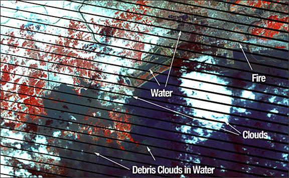
During and after the Earthquake in Japan, Earth observation technology including buoys, satellites and other imaging devices have allowed scientists and the media to visualize and track the impact of the event, mitigating loss of life and property and supporting effective rescue efforts. Citizen scientists, using cameras, cell phones, video cameras and other tools also have provided valuable visual insights.

Commercial and government managed satellites are becoming key tools for analyzing earthquake and tsunami damage and allocating resources for recovery. By comparing processed before-and-after images of the Japanese landscape and coastline, Japanese officials are able to evaluate the impact of flooding at specific locations. At the same time, organizations which aggregate imagery are working in collaboration with national and international relief organizations to provide timely analysis of situations including the deteriorating status of the nuclear reactors in Japan. The earthquake has been officially upgraded to a magnitude of 9.0.


Eartzine on March 18, 2011
Mon, 21 Mar 2011 - 10:05
Japan

Footer menu

  • Contact
  • Terms of Use

User account menu

  • Log in