• English
  • Español
  • Français

United
Nations


Office for Outer Space Affairs
UN-SPIDER Knowledge Portal

  • Accueil
  • À propos
    • Qu'est-ce que l'ONU-SPIDER?
    • À propos d’UNOOSA
    • Publications
    • Offres d'emploi
    • Rencontrez l'équipe
    • Contact
  • Applications spatiales
    • Technologie satellitaire
    • Mécanismes d’urgence
    • Recovery Mechanisms
    • Réseau international d'alerte aux astéroïdes
    • Space Mission Planning Advisory Group
    • Initiative internationale sur la météorologie spatiale
    • Les technologies spatiales à l'ONU
    • Comptes-rendus d'utilisateurs
  • Liens & ressources
    • Application de données du mois
      • Disaster Recovery
    • Sources de données
    • SIG et logiciels de télédétection
    • Online Learning Resources
    • Institutions
  • Risques & catastrophes
    • Prévention des risques de catastrophe
    • Systèmes d'alerte précoce
    • Gestion des catastrophes et des interventions d'urgence
    • Aléas naturels
    • Cadre d'action de Sendai
    • L'ONU et la prévention des risques de catastrophe
    • L'ONU et les alertes précoces
    • L'ONU et la gestion des catastrophes
  • Appui technique
    • Missions Conseil
    • Appui d’urgence
    • Appui à distance
    • Pratiques recommandées
    • Activités de formation
    • Utilisations pratiques
  • Réseaux
    • Bureaux régionaux d’appui
    • GP-STAR
    • MHEWS
    • IWG-SEM
  • Projets
    • SPEAR
    • SEWS-D
    • EvIDENz
    • Flood GUIDE
  • Actualités
    • Actualités
    • Événements
    • Événements passés
  • Admin
    • SAM Items

Breadcrumb

  • Home
  • 7.6 Earthquake Strikes Costa Rica
  • 7.6 Earthquake strikes Costa Rica

7.6 Earthquake strikes Costa Rica

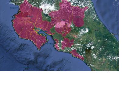
Map of the municipalities affected

The coast of Costa Rica was struck on 5 September 2012 at 08:42 a.m. local time by a major earthquake with the epicenter located in the Nicoya Península. The United States Geological Survey (USGS) indicated a magnitude of 7.6. on the Richter scale. The epicenter is located very close to the surface, approximately in a depth of 10 kilometres. A tsunami warning was in effect for Costa Rica, Panama and Nicaragua, issued by the Pacific Tsunami Warning Centre but it was cancelled two and a half hours later based on data gathered from tide gauges. A map displaying the epicenter was provided by Geographer Douglas Salgado from the National Emergency Commission of Costa Rica (CNE).

The CNE (National Emergency Comission) declared a red alert in all the country and requested to the Municipal Emergency Committees:

- To elaborate a report regarding the main effects and casualties

- To review the supplies and request more supplies if necessary

- To watch over the affected areas

- To pay attention to the requirements and requests regarding the affected populations.

CNE is conducting a damage assessment and CATHALAC, UN-SPIDER's Regional Support Office (RSO) in Panama has tasked NASA's EO-1 satellite to acquire satellite imagery of the areas affected by the earthquake. UN-SPIDER has additionally contacted its RSO in Colombia (IGAC) and CONAE in Argentina.

Read more: USGS, National Commission on Risk Prevention and Emergency Response of Costa Rica (spanish)
Thu, 6 Sep 2012 - 12:29
Costa Rica
Argentina Regional Support Office
Colombia Regional Support Office
Water Center for the Humid Tropics of Latin America and the Caribbean (CATHALAC)

Footer menu

  • Contact
  • Terms of Use

User account menu

  • Log in