United
Nations
Office for Outer Space Affairs
UN-SPIDER Knowledge Portal
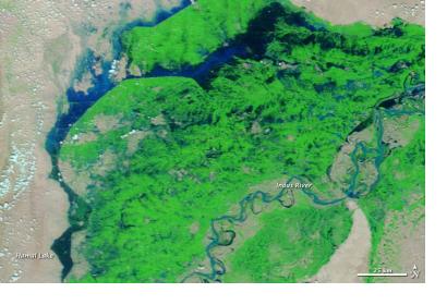
The summer of 2012 marked the third consecutive monsoon season in Pakistan that caused widespread flood damage. These images show part of the irrigation infrastructure. Both images show flood conditions, but flood waters shifted between the date of the earlier image, acquired September 19, 2012, and the later image, acquired October 5, 2012. Acquired by the Moderate Resolution Imaging Spectroradiometer (MODIS) on NASA’s Terra satellite, these images use a combination of visible and infrared light to increase contrast between water and land. Water varies in color from electric blue to navy. Vegetation is bright green, and bare ground is pink-beige. Clouds are pale blue-green and cast shadows. The irrigation infrastructure can be identified by its straight contours. In the more recent image, flood waters have receded in the northwest but increased around Hamal Lake.
