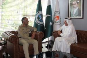
The Ambassador of Kuwait to Pakistan recently met with the Chairman of the National Disaster Management Authority (NDMA) to discuss potential strategies for participative investment in pre-disaster planning and management.
At the meeting, the Chairman of NDMA conveyed his appreciation to the Government of Kuwait and the Pakistani diplomatic team for their generous assistance during the floods in 2022. Additionally, he highlighted the importance of leveraging modern technology to establish a networked satellite intelligence system on climate-based interfaces. The Chairman also highlighted the NEOC as a model disaster mitigation and management hub for the region and expressed plans to replicate it on a provincial level.
The Ambassador of Kuwait appreciated the NEOC initiative and agreed to collaborate on pre-disaster planning and management. The importance of continued support for disaster mitigation, including sharing satellite feeds and software for pre-disaster…
more


")
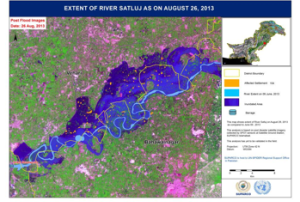
 on the Arabian Sea (Image: ESA)")
")
")
")
")
")
 on NASA’s Terra satellite captured this image of the floods. (Image: NASA)")


 Meeting at SUPARCO's headquarters")