United
Nations
Office for Outer Space Affairs
UN-SPIDER Knowledge Portal
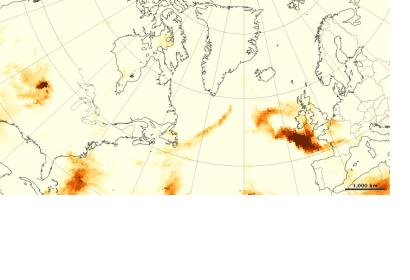
Satellite observations suggest fires in Quebec sent smoke billowing across the Atlantic; but pinpointing the source can pose a scientific challenge, as NASA points out in a recent web article.
Wildfire smoke is a combination of gases and aerosols—tiny solid and liquid particles suspended in air. The maps attached are made from data collected by the Ozone Mapper Profiler Suite (OMPS) on the Suomi National Polar-orbiting Partnership (Suomi-NPP) satellite. They show relative aerosol concentrations, with lower concentrations appearing in yellow and higher concentrations appearing in dark orange-brown. Areas in gray represent data that was not available.
On June 23, 2013, OMPS detected a plume dense with smoky aerosols over the North Atlantic Ocean, east of Newfoundland. The plume blew east on the 24th and reached France by June 25. While wildfires in Colorado may have contributed to the plume, a trajectory analysis by Alain Malo, a meteorologist from the Meteorological Service of Canada, suggests that much of the smoke actually came from Quebec.
