United
Nations
Office for Outer Space Affairs
UN-SPIDER Knowledge Portal
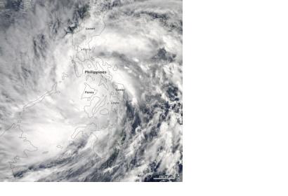
The Moderate Resolution Imaging Spectroradiometer (MODIS) on NASA’s Aqua satellite acquired am image of Super Typhoon Haiyan over the Philippines on 8 November 2013. The image was acquired at 2:10 p.m. local time (5:10 UTC), when winds were estimated to be 270 km/h (165 mph). On 7 November, NASA had already captured the storm from Space before it made landfall.
NASA reported: "Super Typhoon Haiyan (locally named Yolanda) made its first landfall at 4:40 a.m. local time (20:40 Universal Time) on November 7. Preliminary reports suggested the storm roared ashore near Guinan (Samar Province), where ground stations recorded sustained winds of 235 kilometers (145 miles) per hour and gusts to 275 kilometers (170 miles) per hour. According to remote sensing data from the Joint Typhoon Warning Center, sustained winds approached 315 kph (195 mph) just three hours before landfall, with gusts to 380 kph (235 mph)."
