Heavy monsoon rains initiated flash floods in Azad Kashmir, Punjab and Gilgit-Baltistan regions of Pakistan during the first week of September 2014. The heavy rains and flash floods overflowed rivers Chenab and Jhelum, destroying hundreds of houses causing human and property losses. The damages included destruction of houses and buildings, road infrastructure, breaching in canals, collapsing of bridges, damages to rice, cotton, sugar cane crops and inundation of agriculture land.
The Flood Forecasting Division (FFD) of the Pakistan Metrological Department issued a flood alert on 4 September 2014, highlighting the likelihood of very high flooding in River Chenab, Jhelum and Ravi. The National Disaster Management Authority (NDMA) and Provincial Disaster Management Authority (PDMA) of Punjab requested the Space and Upper Atmosphere Research Commission (SUPARCO) of Pakistan to provide pre-flood images of Chenab and Jhelum Rivers and also to provide technical assistance during the ongoing monsoon spell.
SUPARCO, which is also a UN-SPIDER Regional Support Office, closely monitored the 2014 floods, soon after the issuance of the flood alert on 4 September. SUPARCO deployed a technical expert to the Provincial Disaster Management Authority’s office in Lahore and provided pre-flood maps of flood-affected rivers along with maps showing hydrographs (discharge data) of rivers at key locations. A thematic map highlighting deaths/injuries in each affected districts and losses and damages to infrastructure were also forwarded to concerned agencies.
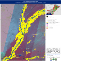
SUPARCO generated Rapid Maps of 29 districts showing inundation and flood extents in each district which were uploaded to the web for interactive visualization of the daily inundation extent.
Based on rapid mapping and detailed damage assessment, the following imagery derived products were provided to the National and Provincial Disaster Management Authorities.
- Cumulative flood extent map on daily basis
- Rapid Damage Assessment- Inundated infrastructure, Inundated Agriculture and Embankments
- Monitoring of Breaches (Pre and Post breach maps)
- Crop damage assessment (Major Crops)
- Pondage water maps showing flood water pockets in low lying areas
- Flythrough simulations of River Chenab generated from satellite imagery vii. Inundation simulation of Punjnad to Sukkar Barrage based on Rainfall Runoff Inundation (RRI) Model
- Thematic maps showing 7-day profile hydrographs (based on river discharge data) on Khanki, Qadirabad, Trimmu Barages
- Scenario map of Athara Hazari prior to breach operation identifying settlements at risk. The breaching section was operated one day later.
- Monitoring of Recession of water and drainage advisory to Irrigation Department
- Map showing status of embankments/obstruction and vulnerable bunds in Indus Flood plain xii. SUPARCO also provided training to the staff of District Coordination Offices (DCO) of 16 most affected districts about satellite-based assessment and interpretation of satellite images.
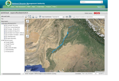
In order to develop an effective flood monitoring framework for rapid information dissemination, a web portal (SUPARCO FloodWatch 2014) was developed and integrated into NDMA's national Disaster Information website. The flood portal was made accessible via http://disasterinfo.gov.pk/floodwatch/ link.
The overall Recovery Need Assessment (RNA) report was presented to the Government of Pakistan by the National Disaster Management Authority on 11 November 2014. In this report, in addition to the in-situ field information provided by Provincial Government Departments, satellite-based information proved very significant in estimation of losses in crops, irrigation infrastructure and other sectors in the flood affected areas.


