• English
  • Español
  • Français

United
Nations


Office for Outer Space Affairs
UN-SPIDER Knowledge Portal

  • Accueil
  • À propos
    • Qu'est-ce que l'ONU-SPIDER?
    • À propos d’UNOOSA
    • Publications
    • Offres d'emploi
    • Rencontrez l'équipe
    • Contact
  • Applications spatiales
    • Technologie satellitaire
    • Mécanismes d’urgence
    • Recovery Mechanisms
    • Réseau international d'alerte aux astéroïdes
    • Space Mission Planning Advisory Group
    • Initiative internationale sur la météorologie spatiale
    • Les technologies spatiales à l'ONU
    • Comptes-rendus d'utilisateurs
  • Liens & ressources
    • Application de données du mois
      • Disaster Recovery
    • Sources de données
    • SIG et logiciels de télédétection
    • Online Learning Resources
    • Institutions
  • Risques & catastrophes
    • Prévention des risques de catastrophe
    • Systèmes d'alerte précoce
    • Gestion des catastrophes et des interventions d'urgence
    • Aléas naturels
    • Cadre d'action de Sendai
    • L'ONU et la prévention des risques de catastrophe
    • L'ONU et les alertes précoces
    • L'ONU et la gestion des catastrophes
  • Appui technique
    • Missions Conseil
    • Appui d’urgence
    • Appui à distance
    • Pratiques recommandées
    • Activités de formation
    • Utilisations pratiques
  • Réseaux
    • Bureaux régionaux d’appui
    • GP-STAR
    • MHEWS
    • IWG-SEM
  • Projets
    • SPEAR
    • SEWS-D
    • EvIDENz
    • Flood GUIDE
  • Actualités
    • Actualités
    • Événements
    • Événements passés

Breadcrumb

  • Home
  • IGAC: Development of Forest Fire Detection And Classification App
  • IGAC: Development of Forest Fire Detection and Classification App

IGAC: Development of Forest Fire Detection and Classification App

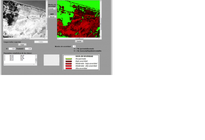
Classification of a Forest Fire in Salamanca Island Road Park, Colombia, based on a 8 LDCM Landsat imageClassification of a Forest Fire in Salamanca Island Road Park, Colombia, based on a 8 LDCM Landsat image (Image: IGAC)

The Research and Development in Geographic Information Centre (CIAF) of IGAC, UN-SPIDER's Regional Support Office in Colombia, is working on the development of tools for disaster management and disaster relief.

One of its products is an application called SEMARK (Forest Fire Severity Markov Classification), which is the result of research conducted within the framework of a PhD thesis on the use of remote sensing techniques in forest fires.

SEMARK creates classifications of spectral indices derived from satellite imagery (NBR, NDVI, and SAVI) classifiers using Markov random fields (MRF). Based on the results, SEMARK can be used as an initial tool in the identification and quantification of areas affected by forest fires.

More information: alexander.ariza@igac.gov.co and sergio.rojas@igac.gov.co

Wed, 17 Sep 2014 - 10:21
Colombia
Colombia Regional Support Office

Footer menu

  • Contact
  • Terms of Use

User account menu

  • Log in