• English
  • Español
  • Français

United
Nations


Office for Outer Space Affairs
UN-SPIDER Knowledge Portal

  • Accueil
  • À propos
    • Qu'est-ce que l'ONU-SPIDER?
    • À propos d’UNOOSA
    • Publications
    • Offres d'emploi
    • Rencontrez l'équipe
    • Contact
  • Applications spatiales
    • Technologie satellitaire
    • Mécanismes d’urgence
    • Recovery Mechanisms
    • Réseau international d'alerte aux astéroïdes
    • Space Mission Planning Advisory Group
    • Initiative internationale sur la météorologie spatiale
    • Les technologies spatiales à l'ONU
    • Comptes-rendus d'utilisateurs
  • Liens & ressources
    • Application de données du mois
      • Disaster Recovery
    • Sources de données
    • SIG et logiciels de télédétection
    • Online Learning Resources
    • Institutions
  • Risques & catastrophes
    • Prévention des risques de catastrophe
    • Systèmes d'alerte précoce
    • Gestion des catastrophes et des interventions d'urgence
    • Aléas naturels
    • Cadre d'action de Sendai
    • L'ONU et la prévention des risques de catastrophe
    • L'ONU et les alertes précoces
    • L'ONU et la gestion des catastrophes
  • Appui technique
    • Missions Conseil
    • Appui d’urgence
    • Appui à distance
    • Pratiques recommandées
    • Activités de formation
    • Utilisations pratiques
  • Réseaux
    • Bureaux régionaux d’appui
    • GP-STAR
    • MHEWS
    • IWG-SEM
  • Projets
    • SPEAR
    • SEWS-D
    • EvIDENz
    • Flood GUIDE
  • Actualités
    • Actualités
    • Événements
    • Événements passés

Breadcrumb

  • Home
  • Viet Nam And India Cooperate In Remote Sensing Technology
  • Viet Nam and India cooperate in remote sensing technology

Viet Nam and India cooperate in remote sensing technology

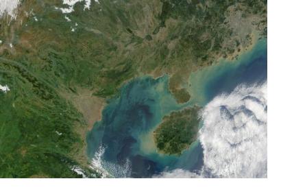
True color satellite image of the Gulf of Tonkin in Vietnam (Image: NASA)True color satellite image of the Gulf of Tonkin in Vietnam (Image: NASA)

The Vietnamese Ministry of Natural Resources and Environment and the Indian Department of Space will promote cooperation in remote sensing and outer space technology via joint projects in human resources training and in applying remote sensing technology.

According to an article in Vietnamplus, the two sides made the joint decision during working sessions between a delegation of the Vietnamese ministry, which made a three-day visit to India recently, and officials from India’s Ministry of External Affairs, Department of Space, and Space Research Organisation. 

Both are making preparations for establishing a centre for satellite tracking, data reception and processing for the Association of Southeast Asian Nations (ASEAN). The center will be located in Vietnam where Vietnamese personnel will be trained to operate the center. India will pay for the installation and operation costs for the project in the first five years, and supply remote sensing images free of charge to ASEAN member states for five years. 
Vietnam
Mon, 18 May 2015 - 16:08
India
Viet Nam

Footer menu

  • Contact
  • Terms of Use

User account menu

  • Log in