Mass movements can be defined as as any type of downslope movement of earth materials, such as sediment, soil and rock material. Mass movements are processes of erosion, transport and accumulation of material that occur on both gentle and steep slopes mainly owing to gravitational forces (IRDR Glossary).
These movements are generally associated with other disasters such as earthquakes, floods, thunderstorms and heavy rainstorm. They can be also associated with manmade hazards like construction roads, buildings, structures, infrastructure facilities.
Facts and figures
Mass movements occur based on several factors and causes differ depending on different regions. Mass movements are affected by the slope gradient, climate, rock type and structure, physical setting and geological and geomorphological outlines (Advances in Geosciences).
Mass-wasting events come in many shapes, sizes and speeds. Typically, the steeper the angle of a slope, the faster will be the down-slope movement of rock and sediment. Also, water can play a significant role in mass wasting, sometimes acting as the key component to a mass-wasting event, or serving as a lubricant within a mass of sediment and rock, enabling it to travel faster and further than it would otherwise.
One type of mass wasting can evolve into another type of mass wasting as the body of sediment/rock moves down a slope. This can make it difficult to classify a single event as being one type of mass wasting or another (Department of Geological Sciences, California State University).
A simple classification of the different types of mass wasting can be:
Falls (rock fall and rock avalanche)
Slides (rock slide, landslide and slump)
Flows (rock avalanche, debris flow, earth flow and creep).
Landslides occur frequently throughout Indonesia, and at a much higher rate when compared to other natural disasters such as floods, windstorms and earthquakes, with 7024 incidents occurring in the last decade. The Head of the BRIN Geoinformatics Research Center spoke on how improvements in remote sensing technology have enabled the production of high resolution imagery that can be used to detect land cover changes and map hazards like landslide occurrences. Additionally, the accessibility of publicly available datasets and imagery has grown, making such practices more cost effective as well.
With the continual developments in the field of remote sensing, BRIN and other research organizations will be able to to study the occurrences of…
L'Institut Géographique Agustin Codazzi (IGAC) de Colombie et l'UNOOSA ont signé un accord de coopération pour établir un Bureau Régional de Soutien de UN-SPIDER en 2011. L'IGAC encourage l'utilisation d'informations spatiales en Colombie à diverses fins et soutient ONU-SPIDER dans les activités menées en Amérique Latine et dans les Caraïbes. En tant que BRA, l'IGAC continue de fournir des experts pour le soutien consultatif technique de ONU-SPIDER aux pays de la région et de contribuer aux efforts de renforcement des capacités dans la région.
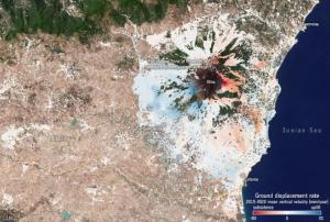
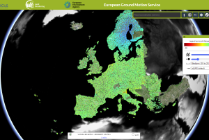
Subsidence processes, sinkholes, or landslides can cause many problems. Even minor subsidence can weaken buildings and infrastructure and lead to issues such as flooding, and in worst cases abrupt disappearance of sections of land. Monitoring and predicting such processes are essential for adopting mitigating strategies.
The new European Ground Motion Service, created and offered by the Copernicus Land Monitoring Service and implemented by the European Environment Agency, provides free and accessible ground motion data.
Based on radar data from Copernicus Sentinel-1 satellite mission, the service provides information on the motion of land, structures and infrastructure in Copernicus Participating States. Its aim is to give users reliable information on ground motion at a local, regional or national scale.
 on top of a mountain. It then pushed mud down across the city of Mocoa (green) and crossed the nearby river. The Sentinel-1-derived data product (from scans on 20 March and 1 April) has been overlaid onto a Sentinel-1 radar image. Image: Modified Copernicus")


 Publishing institution: