  • English
  • Español
  • Français

United
Nations


Office for Outer Space Affairs
UN-SPIDER Knowledge Portal

  • Accueil
  • À propos
    • Qu'est-ce que l'ONU-SPIDER?
    • À propos d’UNOOSA
    • Publications
    • Offres d'emploi
    • Rencontrez l'équipe
    • Contact
  • Applications spatiales
    • Technologie satellitaire
    • Mécanismes d’urgence
    • Recovery Mechanisms
    • Réseau international d'alerte aux astéroïdes
    • Space Mission Planning Advisory Group
    • Initiative internationale sur la météorologie spatiale
    • Les technologies spatiales à l'ONU
    • Comptes-rendus d'utilisateurs
  • Liens & ressources
    • Application de données du mois
      • Disaster Recovery
    • Sources de données
    • SIG et logiciels de télédétection
    • Online Learning Resources
    • Institutions
  • Risques & catastrophes
    • Prévention des risques de catastrophe
    • Systèmes d'alerte précoce
    • Gestion des catastrophes et des interventions d'urgence
    • Aléas naturels
    • Cadre d'action de Sendai
    • L'ONU et la prévention des risques de catastrophe
    • L'ONU et les alertes précoces
    • L'ONU et la gestion des catastrophes
  • Appui technique
    • Missions Conseil
    • Appui d’urgence
    • Appui à distance
    • Pratiques recommandées
    • Activités de formation
    • Utilisations pratiques
  • Réseaux
    • Bureaux régionaux d’appui
    • GP-STAR
    • MHEWS
    • IWG-SEM
  • Projets
    • SPEAR
    • SEWS-D
    • EvIDENz
    • Flood GUIDE
  • Actualités
    • Actualités
    • Événements
    • Événements passés

Breadcrumb

  • Home
  • SPOT 7
  • SPOT 7

SPOT 7

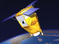
SPOT-7 is a high-resolution wide-swath imaging spacecraft built and operated by Airbus Defence and Space taking over the majority of Spot Image after the government support of the SPOT program was terminated. SPOT-6 – launched in 2012 – and SPOT-7 are identical spacecraft, based on the AstroSat-250 satellite bus and use the NAOMI (New AstroSat Optical Modular Instrument) payload to acquire optical imagery to ensure the continuity of SPOT data, building on experience gained through previous missions, particularly SPOT-5 that launched in 2002.
The SPOT-7 spacecraft is built for a ten-year mission featuring two NAOMI cameras to cover a 60-Kilometer ground swath, 120km using single-pass mosaic imaging. Overall, the satellite can achieve a resolution of two meters in panchromatic and eight meters in multispectral mode covering the visible and near-infrared spectral bands.

Instrument: 2x NAOMI (New AstroSat Optical Modular Instrument)
- 60km swath width
- 5 VIS/NIR channels including one panchromatic. Two units, side-by-side
- push broom

30 Jun 2014
10years
Polar
Sun synchronous
New AstroSat Optical Modular Instrument (2x)
ASTRIUM
Spot Image
exploring the Earth's resources, detecting and forecasting phenomena involving climatology and oceanography, and monitoring human activities and natural phenomena
Sécheresse
Éclatement du lac glaciaire
Efflorescences algales nuisibles
Glissement de terrain
Tremblement de terre
Inondation
Feu de forêt
Mouvement de masse
Tsunami
Éruption volcanique
No
Information about SPOT-7

Footer menu

  • Contact
  • Terms of Use

User account menu

  • Log in