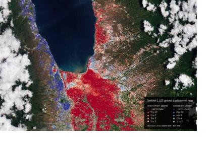
In September 2018, the Indonesian island of Sulawesi was hit by a 7.5 magnitude earthquake. The impact, combined with the tsunami, landslides, and soil liquefaction that followed, “... claimed well over 2000 lives, destroyed homes, buildings, infrastructure and farmland in several districts,” according to the European Space Agency (ESA).
Ten months later, response efforts are now moving into the recovery and rebuilding phase, with satellite information offering important insights to local officials. For example, through a collaboration with the Asian Development Bank, ESA is providing Indonesian officials with hazard-mapping tools derived from Earth observation data, and training in how to most effectively use these resources. “The main purpose of sharing these information products is to help the authorities better understand the hazards associated with seismic activity, flooding and landslides so they can make more informed decisions in elaborating a redevelopment master plan,” according to ESA in a news article about the initiative.
For instance, data acquired from the Copernicus Sentinel-1 radar mission can be used to track ground movement with millimetre precision, enabling cases of land deformation to be detected and monitored. One company, Planetek, which is partnering with ESA in this initiative, has an automatic cloud-based “Rheticus Displacement” monitoring service, from which maps based on this Sentinel-1 data are created. These are particularly helpful in tracking the impact of the 2018 Indonesian earthquake. According to ESA, the maps “... are helping the [Indonesian] authorities evaluate the effect that the disaster has had on the land surface stability.”
The ESA/Asian Development Bank partnership in Indonesia has also involved a week-long course organized by the Asian Development Bank and the Indonesian National Institute of Aeronautics and Space, dedicated to explaining how to use satellite data products. Through the partnership, the Indonesian government is also encouraged to make use of ESA’s online Geohazard Exploitation Platform, which allows users to identify and evaluate seismic risks, volcanoes, subsidence and landslides.

