![]()
United
Nations
Middle InfraRed Observation of Volcanic Activity (MIROVA - NASA)
| Data provided by: | National Aeronautics and Space Administration (NASA) |
| Data accessibility: | visualization of data (e.g. web GIS or real time monitoring) |
| Link to the data: | |
| Data type: | hazard specific data |
| Hazard: | Volcanic Eruption |
| Disaster cycle phase: | Disaster Risk Management |
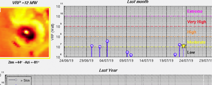
| Space-based Information: | Based on MODIS data, MIROVA detects near real time volcanic hot spots. In order to do so MIROVA analyses the MiddleInfraRed Radiation (MIR) measured over large volcanoes to detect, locate and measure the heat radiation from volcanic activity. This automated thermal monitoring of the most active volcanoes on Earth in near real time provides the user with a quick overview of the latest thermal images which are available for Google Earth overlapping. Additionally, MIROVA provides an updated Volcanic Radiative Power (VRP) time-series in logarithmic and normal scale. MIROVA has been developed as a collaboration between the University of Turin and the University of Florence. |
| Satellites and Sensors: | Terra |
| Spatial coverage: | Global |
| Temporal coverage: | Near-real time |
| Costs: | free |
| Contact: | diego.coppola@unito.it |
Provider
![]()