![]()
United
Nations
Glissement de terrain

Definition
Facts and figures
Further information
UN-SPIDER Regional Support Offices with hazard-specific expertise
Related content on the Knowledge Portal

While several studies have already highlighted how global warming and its consequences are predicted to increase the frequency and magnitude of geohazards such as landslides, the relation between ongoing climate shifts and landslide behaviour is still difficult to assess, especially due to uncertainties in both models. In a new research paper, researchers at NASA's Jet Propulsion Laboratory and collaborating institutions have now documented the transition of a stable, slow-moving landslide into catastrophic collapse for the first time.
Their observations lasted eight years and took place on the California Coast Ranges, which, due to their morphological structure, are an ideal natural laboratory to investigate how stress and fluid pressure changes govern the stable and unstable sliding of landslides. In recent years, more than 650 slow-moving landslides have been identified and mapped in the area. Yet, on May 20, 2017, the Mud Creek landslide…
read more20/02/2019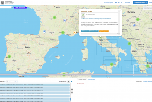 ESA's Earth Observation Thematic Exploitation Platform (TEP) is a browser for satellite imagery and specific products on an environmental topic. The TEP platforms are divided into 7 categories: Coastal; Forstry; Geohazards; Hydrology; Polar; Urban; and Food Security. Each platform is a collaborative, virtual work environment providing access to EO data and the tools, processors and Information and Communication Technology resources required to work with them. TEP aims to bridge the gap between the users and the data and tools.Publishing institution:
The National Aeronautics and Space Administration (NASA) of the United States is currently building a worldwide database of landslide events. The Cooperative Open Online Landslide Repository (COOLR) includes NASA’s Global Landslide Catalog (GLC) which provides new insights into landslide hazards around the world.
The COOLR project is an open platform where scientists and citizen scientists around the world can share landslide reports to guide awareness of landslide hazards for improving scientific modelling and emergency response.
Landslides cause billions of dollars in infrastructural damage and thousands of deaths every year around the world. However, although data on past landslide events guides future disaster prevention, a global picture of exactly where and when landslides occur does still not exist.
There are three main reasons why it is difficult to monitor landslides globally. First, landslides often occur…
read more07/06/2018


-

Term Parents
UN-SPIDER Regional Support Offices with hazard-specific expertise
![]()