![]()
United
Nations
DisasterWatch Desert Locust Situation Alert (SUPARCO)
| Data provided by: | Space and Upper Atmosphere Research Commission (SUPARCO) of Pakistan |
| Data accessibility: | export map, visualization of data (e.g. web GIS or real time monitoring) |
| Link to the data: | |
| Data type: | hazard specific data |
| Hazard: | Insect Infestation |
| Disaster cycle phase: | Disaster Risk Management, Response, Recovery |
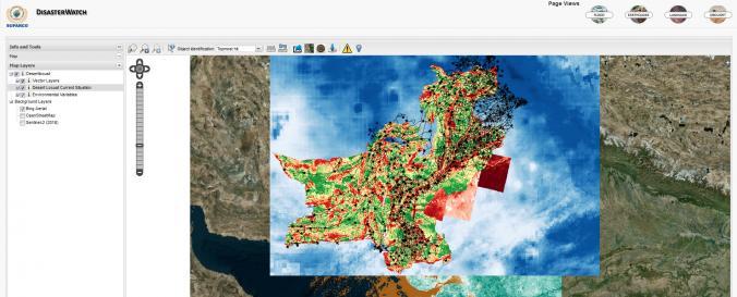
| Space-based Information: | The Space Application Centre for Response in Emergency and Disasters (SACRED) of the Space & Upper Atmosphere Research Commission of Pakistan (SUPARCO), a UN-SPIDER Regional Support Office, is using space-based information to analyze areas as to their suitability as desert locust habitats. The maps resulting form this analysis indicate the suitability of habitat on a scale consisting of five values: least, less, normal, moderate and most. The maps are published online for download, and a related layer is produced and made available through the DisasterWatch Desert Locust Situation Alert geoviewer. |
| Spatial coverage: | Pakistan |
| Temporal coverage: | Near-real time |
| Costs: | free |
Provider
![]()