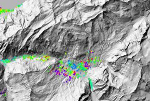
Archived radar data from the Envisat mission are playing an important role in mapping landslides in Switzerland. The mission’s vast archives continue to prove useful for mapping ground deformation. Landslides are a natural hazard of special relevance in Alpine regions. Earth-observing satellites – specifically those equipped with radars – can help scientists to map and monitor ground movement. From their orbits some 800 km above the ground, satellite radars can detect these ground deformations down to within centimeters. When two or more radar images of the same area are combined, positional changes are revealed. This technique, called Differential Interferometric Synthetic Aperture Radar – or DInSAR – has become a useful tool for detecting ground deformation. The Swiss corporation Gamma Remote Sensing began using DInSAR on Swiss landslides with data from ESA’s ERS missions in 2000. Following Envisat’s launch in 2002, they continued to…
more
United
Nations
Switzerland
country taxonomy block
Three key research centers and a consortium of Internet companies said on Thursday they would work together on a European cloud computing platform to handle the continent's rapidly growing demand for computer capacity.
A statement from CERN, the Geneva-based particle physics organization, said the platform -- dubbed "Helix Nebula-the Science Cloud" -- would be made available to government bodies and industry after a two-year pilot phase. Also participating in the program are the European Space Agency (ESA) and the German-based European Molecular Biology Laboratory (EMBL), which like CERN are gathering vast volumes of information that cannot presently be processed. The 13 information technology providers involved include French-based Atos, Paris-based Cap Gemini, UK-based Logica, French-based Orange Business Services, Spain's Telefonica and French-based Thales, the statement said. "This pan-European partnership across academia and industry ...…
moreAn international information system designed to improve and expand the exchange of data on weather, climate and water will help boost food security around the world, according to the World Meteorological Organization (WMO). The UN agency, which launched the system last month (31 January), said it would improve access to meteorological observations and products for stakeholders including the research and disaster risk reduction sectors. David Thomas, chief of the WMO's information and telecommunication system division, told SciDev.Net that the system could bolster food security because crop yield and agriculture depend on variations in the weather, seasons and climate. The WMO can provide many useful services to decision-makers, he said. "For instance, seasonal predictions and climate outlooks are powerful tools for knowing what crops or agriculture will be more likely to be productive, while routine weather forecasts and mid-range outlooks can have strong impacts on harvesting…
moreRadio frequencies which are vital for weather forecasts, disaster warnings and climate monitoring will remain available to the meteorological community and protected from interference from other applications thanks to decisions taken by the World Radiocommunication Conference 2012 (WRC-12). The World Meteorological Organization today welcomed the outcome of WRC-12 and said it would safeguard the use of radio frequency spectrum which are needed to observe and understand our Earth, atmosphere and oceans and to reduce the risk of weather, climate and water-related disasters. WRC-12 reinforced the commitment of previous World Radiocommunication Conferences to the special needs of meteorological and hydrological services, despite competing pressure for scarce radio frequencies from wireless technology and other uses.
"New applications for radio waves are being continuously developed, which means that more and more has to be squeezed into the available radio spectrum,”…
moreThe United Arab Emirates, represented by Tarek Al Awadhi, Head of the Spectrum & International Affairs Section at the Telecommunications Regulatory Authority (TRI), was selected as a chair of the World Radiocommunication Conference (WRC-12) which opened in Geneva today. This is the first time the UAE has chaired the conference since joining in 1972.
The conference is aimed at reviewing and revising the Radio Regulations, the international treaty governing the use of radio-frequency spectrum and satellite orbits.
The UAE delegation to the conference is headed by TRA’s Director General Mohammed Nasser Al Ghanim.
The work of this international treaty-making Conference will be conducted over four weeks until 17 February to address the changes required to the regulation of orbit/spectrum resources in the interest of the users of these scarce resources, with global implications for policy-makers, regulators, the industry as well as end-users.
Over…
moreThe SPIDER Global Thematic Partnership (SPIDER GTP) which was launched in 2009 was again present in the 3rd Session of the Global Platform, which was organized and conducted by the United Nations International Strategy for Disaster Reduction (ISDR) from 9 to 13 May 2011 on the premises of the Geneva International Convention Center.
This session of the Global Platform brought together more than 2600 representatives from a variety of agencies from national governments, regional and international organizations, academia, NGOs, and from the private sector. Taking advantage of the format of the event which included several side sessions, the SPIDER GTP brought together high ranking authorities and experts from the Asian Disaster Reduction Center (ADRC), the International Society of Photogrammetry and Remote Sensing (ISPRS), the Joint Board of Geospatial Information Societies (JBGIS), the German Aerospace Center (DLR), and Esri in a side event titled: “Integrated Use of Space…
moreThe World Bank is calling for innovative ideas to solve challenges in disaster recovery and reconstruction, ahead of the World Reconstruction Conference, the first large-scale global conference to focus on natural hazard recovery and reconstruction. The event will take place in Geneva Switzerland from 10-13 May 2011, as part of the Third Global Platform for Disaster Risk Reduction.
Who can participate?
Anybody with an innovative project for disaster recovery and reconstruction! The World Reconstruction Conference Innovation Competition is open to all individuals, teams, and organizations (NGOs, private companies, or public entities). What is it about? New and innovative ways of addressing challenges in disaster recovery and reconstruction play an important role in natural disasters. To help identify and tap the best of these innovative approaches, an Innovation Competition – New Approaches to Disaster…
moreJoin geospatial professionals from international organizations and non-governmental/nonprofit organizations at the 2015 GIS for the United Nations and the International Community Conference from May 18 to 20, 2015 at Campus Biotech in Geneva, Switzerland. Learn how GIS can help you identify and map the locations of vulnerable populations, communicate complex situations with simple web maps, plan where to execute program activities to meet objectives and deliver results, and more.
Don’t miss this chance to further your professional development, get up to speed on the latest updates to the ArcGIS Platform, and connect with other groups that use GIS to transform our world. The event is jointly hosted by UNITAR’s Operational Satellite Application Programme (UNOSAT) and Esri.
Registration and the agenda for 2015 will be available soon. Come, be inspired, and discover how geography and location-aware applications can improve the effectiveness of your programs and missions.
AI for Good is the United Nations’ leading platform for harnessing artificial intelligence to address global challenges. It brings together a diverse network of stakeholders, including policymakers, researchers, industry leaders, and civil society, to explore and promote the responsible and impactful use of AI technologies.
Organized by the International Telecommunication Union (ITU) in partnership with over 40 UN sister agencies and co-convened with the Government of Switzerland, AI for Good aims to accelerate progress on sustainable development goals by identifying innovative AI applications, building global skills and standards, and fostering collaborative partnerships.
The platform promotes the development of AI standards to drive innovation and digital transformation while ensuring safety, fairness, and inclusivity. It also supports AI education and capacity-building, equipping people around the world with the…
more
On 26 December 2004, an earthquake in the Indian Ocean caused a devastating tsunami that killed around 230,000 people in 14 countries. It remains one of the deadliest disasters in recent human history.
The people who lived through this tragedy are forever changed by it. That is why this year, World Tsunami Awareness Day (WTAD) is honouring the memory of the Indian Ocean Tsunami on its 20th anniversary and highlighting major advances on protecting people since.
This exhibition tells the powerful accounts of tsunami survivors alongside contemporary artworks that capture the sea change of perspective that the aftermath brought, with unprecedented global collaboration on disaster resilience. Everyone must be tsunami ready - recognise the warning signs, be protected by early warning systems and be able to act quickly and get to high ground. We must have resilient infrastructure so livelihoods are not destroyed and build back better when tsunamis hit.
Tsunamis are rare…
more
The Global Platform for Disaster Risk Reduction (GP) is the global forum where participants take stock of progress, share new knowledge, exchange best practice and discuss the latest developments and trends in reducing disaster risk.
The UN General Assembly recognizes the Global Platform for Disaster Risk Reduction as a critical mechanism to review progress on the implementation of the Sendai Framework for Disaster Risk Reduction. At the Platform, governments, the UN system and all stakeholders get together to identify ways to further accelerate the implementation of the Sendai Framework. Since 2007, seven sessions of the Global Platforms have taken place. The outcomes are recognized by the General Assembly and the Economic and Social Council as a contribution to the deliberations of the High-Level Political Forum on Sustainable Development (HLPF) and thus, contributing to risk-informed implementation and monitoring of the 2030 Agenda for Sustainable Development.
…
more
More than 60 humanitarian networks and partnerships are invited to hold their meetings and organize joint sessions at the "Humanitarian Networks and Partnerships Week" (HNPW). HNPW 2024 will be held in a hybrid format from April 29 to May 10, 2024. The first week (April 29 to May 3) will be held remotely, while the second week (May 6 to May 10) will be organized face-to-face at the CICG in Geneva.
Nine areas of common concern will be addressed for inter-network collaboration. These are:
1. Accountability to Affected Populations
2. Anticipatory Action
3. Climate Crisis
4. Emergency Response in a Pandemic
5. Inclusion
6. Integrating Security Risk Management in Humanitarian Action
7. Localization
8. Nexus
9. Organizational Culture and Power Relations
The United Nations Office for Outer Space Affairs, the World Health Organization and the United Nations Conference on Trade and Development are co-organizing, in collaboration with the Government of Switzerland and Space and Global Health Network hosted by the Geneva Digital Hub, the International Conference on Space and Global Health to raise awareness, build capacity and increase collaboration between the space domain and the global health domain, by inviting decision-makers and practitioners from both domains to share their experiences.
The Conference will provide a forum for discussion around the different aspects of how space can contribute to global health, in a holistic manner, seeking to contribute to the implementation of the United Nations General Assembly resolution on Space and Global Health A/RES/70/120 and support Sustainable Development Goal 3 "Good Health and Well-Being".
The Conference will focus on the areas identified by the Working Group of the…
more
The Humanitarian Networks & Partnerships Week (HNPW) conference is an annual humanitarian event that provides a collaborative space for experts, stakeholders and practitioners from a diverse array of organisations -UN agencies, IFRC, NGOs, military, private sector, academia, and Member States- that can express their experiences, introduce new ideas and tools, and connect and cooperate in finding solutions to common challenges in crisis preparedness and response.
This year’s HNPW conference will be held in a hybrid format, combining remote sessions (17-21 April) with face-to-face and hybrid sessions at the CICG (Geneva) (24-28 April).
To have a look at this year's HNPW programme, click here. Among the…
more
The Data Working Group, together with the GEOSS Platform and the GEO Knowledge Hub teams, will host a two-day workshop on Open Data and Open Knowledge from June 15-16, 2023. The event will provide the GEO community with an opportunity to discuss technical advances, challenges, and solutions related to open knowledge practices. The event follows the endorsement of the GEO Statement on Open Knowledge in 2021 and seeks to empower all users to access and use open EO-based applications in the various engagement priorities and main conventions.
The objectives of the workshop are to highlight the ongoing efforts of the GEO community towards open and reproducible knowledge, promote open knowledge applications to the youth community, as well as to less represented communities, and align the GEO community and its activities with the open and reproducible knowledge vision. Furthermore, the event aims to explore and discuss technological advances that facilitate the implementation of…
more
The GEO Symposium 2023 is set to take place in person in Geneva on June 13-14, 2023, followed by the Open Data and Open Knowledge Workshop. This year's event marks a significant milestone for the global Earth observation community, as it will be the first in-person symposium since 2019.
The annual symposium, hosted by the Group on Earth Observations (GEO), provides a platform for members of the GEO Work Programme community to exchange knowledge, share experiences, and foster collaboration. The theme for the 2023 symposium is "Stand out in the crowd: GEO Work Programme for Nature, People, and Planet."
Participants at the symposium will draw on GEO's previous accomplishments to showcase how GEO can accelerate equitable access to Earth observations and develop and share information that leads to impact. The event will feature a range of interactive dialogue sessions on the GEO Post-2025 strategy and the GEO Work Programme. Thematic sessions of the event will focus on…
moreUnder the theme, "Taking the Pulse of the Planet”, 275 members of the GEO community, from more than 45 countries, will chart the next steps in creating and implementing a Global Earth Observation System of Systems (GEOSS) during the Group on Earth Observations (GEO) Eleventh Plenary Session to be held on 12-14 November in Geneva, Switzerland. One highlight of the conference will be announcement of the winners of the GEO Appathon, a global “app” development competition built on the 80 million-plus resources currently available through GEOSS. The Appathon attracted 250 competitors from 50 countries and will generate easy-to-use decision tools for mobile devices and computers. GEO’s mandate is to harness the power of Earth observations from sources across the globe to provide more and better information to leaders in government, industry, and civil society confronting fundamental decisions affecting people and societies world-wide. Key GEO initiatives that will be highlighted during…
moreThe aim of this Flood Management Course is to provide basic principles and technical overview for flood management
Content:
Basics of flood hazards
•Meteorology
•Flood generation processes
•Sediment transport processes
Flood hazard evaluation (scenarios: inundation, alluviation, erosion)
•Flood hazard modelling
•Flood hazard mapping: hazard map, hazard index & intensity map
Flood management strategies:
•Integrated risk management
…
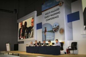
The Sendai Framework for Disaster Risk Reduction 2015-20301 was adopted by 187 United Nations (UN) Member States on 18 March 2015, at the Fourth UN World Conference on Disaster Risk Reduction (WCDRR) in Sendai, Japan, and endorsed by the UN General Assembly in June 2015, with the expected outcome of a “substantial reduction of disaster risk and losses in lives, livelihoods and health and in the economic, physical, social, cultural and environmental assets of persons, businesses, communities and countries” over the following 15 years.
During the negotiations, countries and partners highlighted the need to:
- Continue to invest in, develop, maintain and strengthen people-centred, end-to-end early warning systems
- Promote the application of simple and low cost early warning equipment and facilities
- Broaden the dissemination channels for early warning information to facilitate early action
Countries also called for the further development of…
moreThe aim of the course is to enable participants to work with basic GIS tools and methodologies in preparation of disaster related maps in support of emergency response operations. A central part of the course involves collecting pre and post disaster baseline data from web sources, preparing, and analysing and creating situation maps to support emergency response. Hands on experience with the field data collection tools like GPS, PDA and UAV will also be part of the course.
The learning objectives of the training are: define and describe basic concepts and terminology related to geospatial information technology; apply basic methods and functionalities of GIS software (ESRI ArcGIS) to manage and analyse spatial data; undertake the process of map-making…
more
The AI for Good Global Summit is the leading United Nations platform for global and inclusive dialogue on AI. The Summit is hosted each year in Geneva by the ITU in partnership with UN agencies, XPRIZE Foundation and ACM.
The summit goal is to connect AI innovators with problem owners, to identify practical applications of AI to accelerate progress towards the UN Sustainable Development Goals and ensure trusted, safe and inclusive development of AI technologies and equitable access to their benefits.
The sixth Session of the Global Platform for Disaster Risk Reduction (GP2019) will take place in Geneva, Switzerland from 13 to 17 May, 2019, convened and organized by the UN Office for Disaster Risk Reduction (UNISDR) and hosted by the Government of Switzerland.
The session will be co-chaired by Switzerland and UNISDR. It will represent the next important opportunity for the international community to boost the implementation of the Sendai Framework and related Sustainable Development Goals of the 2030 Agenda, as well as commitments of the Paris Climate Agreement.
It will be the last global gathering for all stakeholders before the deadline for the achievement of Target E of the Sendai Framework: Substantially increase the number of countries with national and local disaster risk reduction strategies by 2020.
The GP2019 will be organized under the overall theme entitled: Resilience Dividend: Towards Sustainable and Inclusive Societies. It will focus on how…
more
The Tech4Dev Conference is the biennial flagship event of the UNESCO Chair in Technologies for Development hosted by CODEV at EPFL. The Conference focuses on the potential of technology solutions to advance inclusive social and economic development in the Global South.Tech4Dev 2018 puts the challenges and the potential of the Global South in the centre of discussions reflected by its title Voices of the Global South.
This conference provides opportunities to:
- Present research at a unique multidisciplinary Conference focused on innovative technology for social impact in the Global South.
- Network across disciplines and fields of technology, to promote the development, deployment, adaptation, and scaling of new solutions for the Global South.
- Identify opportunities for collaboration with diverse stakeholders – academics, students, engineers, entrepreneurs…
