![]()
United
Nations
Éclatement du lac glaciaire

Definition
Facts and figures
Further information
UN-SPIDER Regional Support Offices with hazard-specific expertise
Related content on the Knowledge Portal

A study conducted by Swiss and Chinese scientists assesses the flood danger posed by glacial lakes across the Tibetan Plateau using an automated satellite survey.
Glacial lake outburst floods (GLOFs) are a major concern throughout the Third Pole Environment, where thousands of glacial lakes have formed and continue to expand in response to climate warming and glacial retreat. This is particular true in the Himalaya, where several disasters occurring over the past century have caused significant loss of life and damage to infrastructure. The fear is that these lakes can overtop their barriers and send floods downstream that overrun settlements.
The study looked at 1,300 of these water bodies that have built up in front of ice streams and which are dammed by rocky debris, and identified 210 lakes (16 per cent) with a potential to threaten communities. This information facilitates targeted local monitoring and other risk reduction…
read more23/04/2019
Sentinel Hub, together with the European Earth Observation programme Copernicus and the European Space Agency, are looking for new and innovative ideas and scripts for Sentinel data processing and visualization. The contest will run until 5 May 2019 and all the entries will be judged by a jury of experts on functionality and usefulness, as well as possible commercial value.
The EU Earth Observation Browser and similar services are made possible through open data policies, which allow everyone to access and use satellite data. Thanks to these policies a wide variety of fields are creating applications for satellite data, however, they need support to make use of the data for these applications. Custom scripts are an easy and quick way to add value to already available data and rapidly test new algorithms.
The Sentinel Hub Custom Script Contest is a remotely run hackathon engaging data…
read more23/04/2019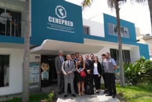 ,
,  ,
, 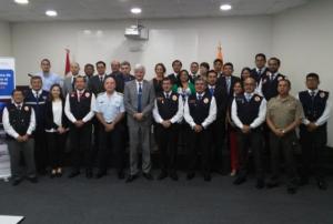
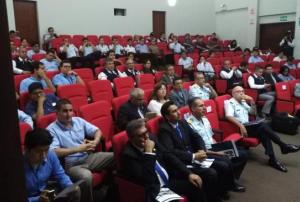
As part of it advisory support activities, UN-SPIDER is carrying out out a Technical Advisory Mission (TAM) to Peru from 1 to 5 April to evaluate the current and potential use of space-based information in all aspects of disaster management. Based on exchanges with a wide range of stakeholders, UN-SPIDER will provide recommendations as to how to strengthen the use of space-based information in disaster risk management and emergency response in the country.
The team of experts led by UN-SPIDER is conducting multiple activities and institutional visits in Lima. The team is comprised of eight experts from UN-SPIDER; the German Aerospace Centre (DLR); the Argentinian National Space Activities Commission (CONAE); the Mexican Space Agency (AEM); the Agustin Codazzi Geographic Institute of Colombia (IGAC); the Santa Maria…
read moreRegional Support Offices mentioned:01/04/2019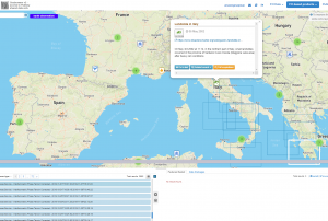 ESA's Earth Observation Thematic Exploitation Platform (TEP) is a browser for satellite imagery and specific products on an environmental topic. The TEP platforms are divided into 7 categories: Coastal; Forstry; Geohazards; Hydrology; Polar; Urban; and Food Security. Each platform is a collaborative, virtual work environment providing access to EO data and the tools, processors and Information and Communication Technology resources required to work with them. TEP aims to bridge the gap between the users and the data and tools.Publishing institution:
ALTIKA, the altimeter and prime payload of the SARAL mission, will be the first spaceborne altimeter to operate at Ka-band (35.75 GHz, 500 MHz). The high-resolution AltiKa altimeter has a dual-frequency radiometric function which allows the altimetry measurements to be corrected for the effects due to the signal passing through the wet troposphere
The Space and Upper Atmosphere Research Commission (SUPARCO) of Pakistan and the United Nations Office of Outer space Affairs (UNOOSA) signed the cooperation agreement on the establishment of a UN-SPIDER Regional Support Office (RSO) on the occasion of the 47th Scientific and Technical Subcommittee sessions on 12 February 2010.
SUPARCO, the national space agency, was established in 1961 as a Committee and was granted the status of a Commission in 1981. SUPARCO is mandated to conduct R&D in space science, space technology, and their peaceful applications in the country. It works towards developing indigenous capabilities in space technology and promoting space applications for socio-economic uplift of the country.
Address:
Pakistan Space and Upper Atmosphere Research Commission (SUPARCO)
Islamabad Highway,
Islamabad-44000 PakistanMission/Objective:
To…
read more
Term Parents
UN-SPIDER Regional Support Offices with hazard-specific expertise
![]()