![]()
United
Nations
Efflorescences algales nuisibles
, processed by ESA, CC BY-SA 3.0 IGO.")
Definition
Facts and figures
Further information
UN-SPIDER Regional Support Offices with hazard-specific expertise
Related content on the Knowledge Portal
 Pleidas, TerraSar-X, SPOT and Elevation data available commercially from airbus, certain sample data sets at various locations available for free.Publishing institution:
 The website: https://www.radiant.earth
Help and Tutorials: https://help.radiant.earth/
Demos & Use Cases: https://demos.radiant.earth/Publishing institution: NASA's Earth Observing System Data and Information System (EOSDIS) is a program for archiving and distributing Earth science data from multiple missions to users.Publishing institution:
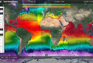 The Ocean Virtual Laboratory is a web platform making satellite and in-situ data for ocean monitoring accessible. It presents one of multiple Syntool Web portals that promote the synergistic use of Ocean Remote Sensing data in a wider context of Oceanic and Atmospheric models or in-situ data. , ESA/SEOM Ocean Virtual Laboratory portal:
SAR roughness Sentinel 1:
Ocean Color: From Sentinel-2, Sentinel-3 and Meteosat.
Chlorophyll: From VIIRS and MODIS
Sea Surface Temperature, Sea level, Salinity, Wind, Current, Rain, Mean Square Slope, Sea ice concentration
, ESA/DUE GlobCurrent portal:
SAR roughness, Ocean Color, Chlorophyll, Sea surface temperature, Sea level, Salinity, Wind, Wave, Current, Rain, ESA SMOS Storm portal: Significant Wave height (SWH) Jason 2 and ALTIKA, SAR roughness Sentinel-1, Wind speed SMOS, SMAP, AMSR2 and ASCAT, wind barbs ASCAT, CNES Aviso'VIZ altimetry portal: Sea Surface Height Anomaly (SSHA) Jason-2 and SARAL, Sea Level Anomaly (SLA) Jason-2 and SARAL, Absolute Dynamic Anomaly (ADT) Jason-2 and SARAL, Mean Sea Level RIse, Sea Level Anomaly, Geostrophic current vectors and streamlines., ESA Sentinel3 Viewer: products from OLCI, SLSTR and SRAL sensors., CNES PEPS Sentinel-1 Ocean Viewer: SAR roughness Sentinel-1, ESA Sea Surface Salinity portal: SMOS salinity, SMAP salinityPublishing institution:-
The Ocean Virtual Laboratory is a web platform making satellite and in-situ data for ocean monitoring accessible. It presents one of multiple Syntool Web portals that promote the synergistic use of Ocean Remote Sensing data in a wider context of Oceanic and Atmospheric models or in-situ data. , ESA/SEOM Ocean Virtual Laboratory portal:
SAR roughness Sentinel 1:
Ocean Color: From Sentinel-2, Sentinel-3 and Meteosat.
Chlorophyll: From VIIRS and MODIS
Sea Surface Temperature, Sea level, Salinity, Wind, Current, Rain, Mean Square Slope, Sea ice concentration
, ESA/DUE GlobCurrent portal:
SAR roughness, Ocean Color, Chlorophyll, Sea surface temperature, Sea level, Salinity, Wind, Wave, Current, Rain, ESA SMOS Storm portal: Significant Wave height (SWH) Jason 2 and ALTIKA, SAR roughness Sentinel-1, Wind speed SMOS, SMAP, AMSR2 and ASCAT, wind barbs ASCAT, CNES Aviso'VIZ altimetry portal: Sea Surface Height Anomaly (SSHA) Jason-2 and SARAL, Sea Level Anomaly (SLA) Jason-2 and SARAL, Absolute Dynamic Anomaly (ADT) Jason-2 and SARAL, Mean Sea Level RIse, Sea Level Anomaly, Geostrophic current vectors and streamlines., ESA Sentinel3 Viewer: products from OLCI, SLSTR and SRAL sensors., CNES PEPS Sentinel-1 Ocean Viewer: SAR roughness Sentinel-1, ESA Sea Surface Salinity portal: SMOS salinity, SMAP salinityPublishing institution: 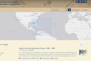 Publishing institution:
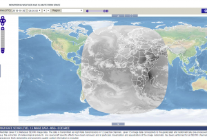 Map Viewer that allows downloading and time series creation of meteosat products.Publishing institution:
 The Copernicus Marine Environment Monitoring Service provides various products and services for marine applications.
These include a global ocean physical analysis and forecast, biogeochemistry analysis and weekly forecast, global ocean waves analysis and forecast and in-situ observations.
To the parameters observed belong: temperature, salinity, chlorophyll concentrations and many more.Publishing institution: NASA’s Ocean Biology Processing Group (OBPG) provides True Color, Chlorophyll and Sea Surface Temperature for download.Publishing institution:
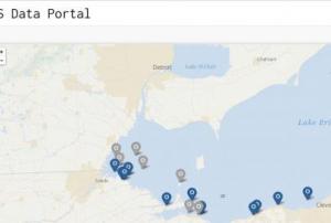 NOAA's Ecoforecasting Map locates site at risk of HABs, names prevalent species at the site and links directly to Alerts and Bulletins (forecasts) for the respective regions.
The HABS Data Portal, is the portal for the great lakes (Lake Erie) mapping in-situ data useful in mapping algal blooms in the region.
The phytoplancton monitoring network is a webmap which includes current weather radar, sampling locations and oceanographic data (SST,Salinity)Publishing institution:
Term Parents
UN-SPIDER Regional Support Offices with hazard-specific expertise
![]()