A state of emergency has been declared on 26 January 2017 in south-central Chile due to the worst forest fires that the region has experienced in its modern history. The fires began in mid-January and spread quickly because of this year’s especially hot and dry summer in South America. The blazes are furthermore amplified by strong winds, high temperatures and a lasting drought that Chile has been experiencing in the last 6 years. As it was commented at the General Assembly of the International Union of Geodesy and Geophysics in 2015, there have been 30-70% annual precipitation deficits in Chile, which have led to an unprecedented drought. (http://dgf.uchile.cl/rene/PRES/abstract_IUGG_MegaDrought.pdf)
According to the BBC, interior Minister Rodrigo Penailillo said that at least 2,000 homes had been destroyed, leaving some 8,000 people with no place to live. One town, Santa Olga, has been completely swept by the blaze. There were 108 active forest fires registered on 23 January and according to the National Forest Corporation (CONAF), 62 of them had been under control and only 3 had been extinguished. Chile’s president Michelle Bachelet said the country had almost exhausted its fire-fighting capacities and asked for international aid. For more information, visit http://www.bbc.com/news/world-latin-america-38713019.
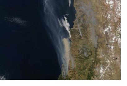
Images of brown smoke were captured on 20th January thanks to NASA’s Terra Satellite’s Moderate Resolution Imaging Spectroradiometer (MODIS).
The International Charter was activated on 24 January 2017. The Center for Satellite Based Crisis Information (ZKI) at the German Aerospace Center (DLR) was designated as Project Manage for this activation. It will provide the Chilean National Emergency Office of the Ministry of Interior (ONEMI) with valuable space-based information, e.g. disaster extent maps or fire maps.
Additional links:http://earthobservatory.nasa.gov/IOTD/view.php?id=89496

