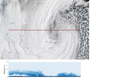
NASA's scientists are researching new information about the Earth's hydrologic cycle by examining satellite radar imagery of extratropical cyclones in the Bering Sea.
Cyclones constitute one of the most widely spread and powerful storm systems on our planet and they generate the majority of fresh water collected at middle and high latitudes. While the phenomena that originates extratropical cyclones is well known, the elements of cloud features constituting these storms are not completely explained.
Consequently, NASA's experts are examining the cloud-storm relationship by looking at the fine-scale features of cyclones in order to assess the feedback on the storm strength and life cycle. Radar technology, such as those of NASA's CloudSat, allows experts to detect the reflections from cloud droplets and ice particles. The higher the amount of water and ice contained in the cloud, the more the energy that the cloud reflects back to the radar. The added value of CloudSat radar is to enable detailed analysis of the middle and upper portions of winter storm clouds, which are invisible with other radars, as well as the intense snow bands reaching the surface.

