The Tonga Preparedness Pilot Project enhances disaster preparedness using remote sensing in Tonga and is a joint initiative by the United Nations Office for Outer Space Affairs (UNOOSA)/UN-SPIDER and the Committee on Earth Observation Satellites (CEOS). The National Disaster Risk Management Office (NDRMO) leads this initiative in Tonga and utilise satellite imagery and advanced EO technologies to enhance our disaster preparedness.
Background Information
The project was developed following the UNOOSA Technical Advisory Mission in December 2023. In this mission, UNOOSA supported Tonga for improved preparedness and demonstrated the usefulness of satellite Earth Observation technologies and its products for Early Warning for All Initiatives (EW4ALL) in pacific islands states. This enabled Tonga to leverage its Pacific Islands Forum chairmanship to showcase innovations with potential for scaling across other large ocean states.
Methods
The Tonga Preparedness Pilot Project, a joint initiative by UN-SPIDER and CEOS, enhances disaster preparedness using remote sensing in Tonga. NDRMO leads this initiative and will utilise satellite imagery and advanced Earth observation technologies to enhance the countries’ disaster preparedness significantly.
To aim at more interactive disaster risk management, the team built the integrated platform for disaster risk management with in-kind contributions of multi stakeholders including private sectors. This platform includes:
- Data Catalogue: all risk data is classified with its metadata according to their categories
- Dashboard: a data storytelling format that includes text, graphics, web resources, documents, and videos, allowing users to navigate through the platform, visualize and analyse data.
- WEBGIS: A GIS interface that helps visualize vector data (such as national and provincial boundaries, seismic data etc.) and raster data, including updated satellite data.
Result
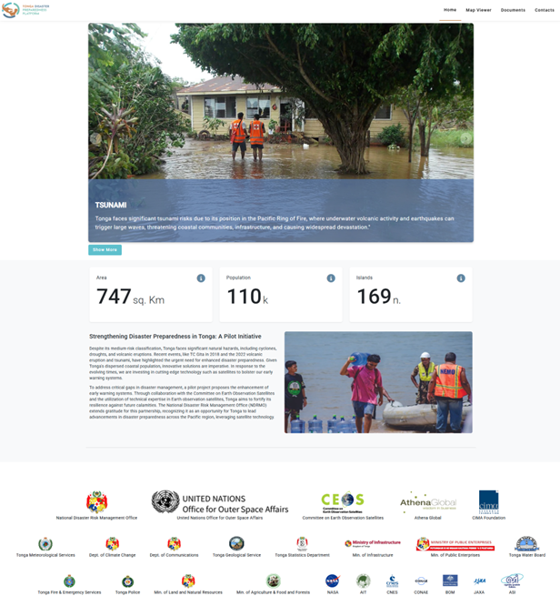
The platform is designed to strengthen national disaster preparedness and response capabilities by utilizing satellite-based Earth observation (EO), GIS technologies, and digital twin applications.
· Tonga Disaster Preparedness Platform: http://tonga.is-portal.org/#/home
Platform Features and Components
- Home Dashboard: The homepage provides an overview of the project’s goals and functions, enabling users to quickly understand the platform’s purpose and navigation structure.
- Data Catalog: The platform hosts a comprehensive catalog of spatial datasets, categorized by themes such as seismic hazards, land use, building footprints, vegetation indices (NDVI/VCI), flood zones, and more. Each dataset includes detailed metadata to ensure transparency and usability.
- Interactive Dashboard: A visual storytelling interface combines maps, charts, text, and multimedia content to present disaster risk insights. It supports decision-makers by offering synthesized, real-time visual analytics.
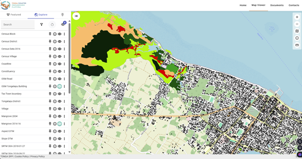
- WebGIS Viewer: A fully functional online GIS interface allows users to overlay and interact with vector (e.g., administrative boundaries, roads) and raster data (e.g., SAR-based deformation, flood maps). Users can perform spatial queries, measure distances, and analyze hazard exposure through intuitive tools.
- Resources Section (Documents and Videos): This component includes satellite analysis reports, technical documentation, and training materials such as videos from capacity-building workshops. It supports user education and the institutionalization of EO-based workflows.
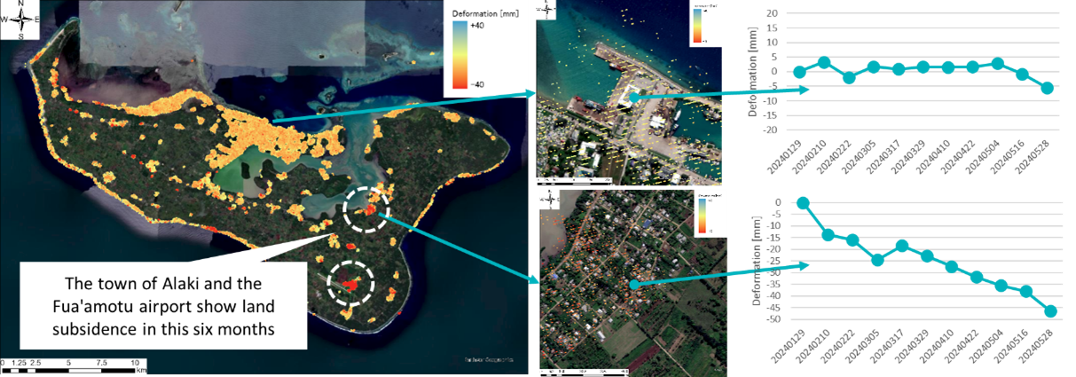
Land Subsidence Monitoring: InSAR analysis over 234,000+ points in Tongatapu using Sentinel-1, ALOS-2, and Cosmo-SkyMed revealed localized subsidence, notably near Alaki and Fua’amotu Airport, but no widespread deformation between January and May 2024.
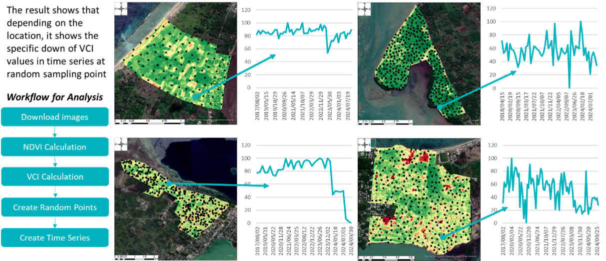
Drought Monitoring: Using PlanetScope optical data, time-series Vegetation Condition Index (VCI) analysis helped assess vegetation health and water stress across the island.
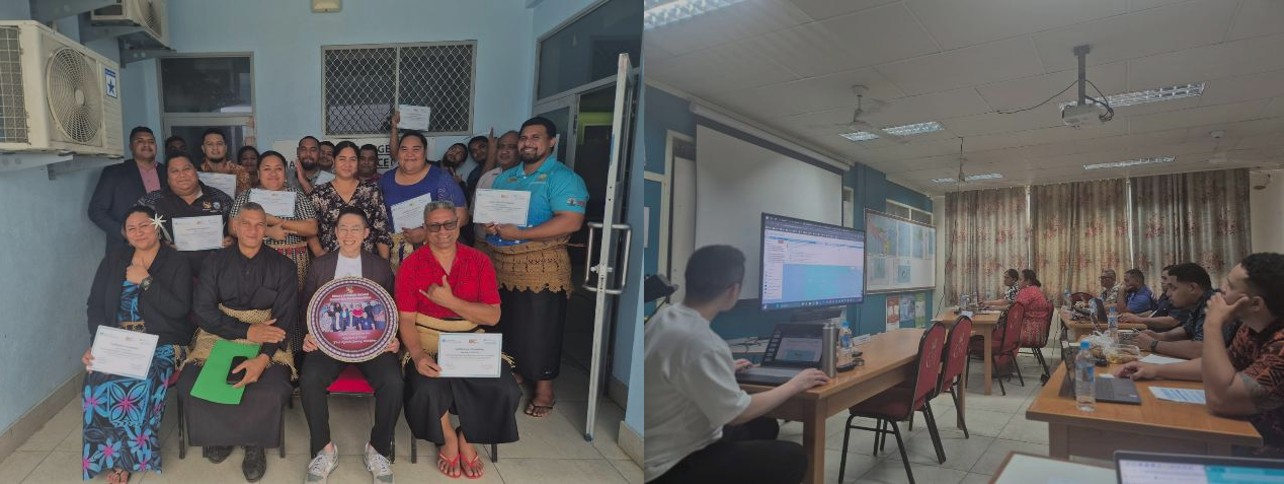
Capacity Building: A national Remote Sensing and GIS Workshop was conducted in December 2024 with participation from key ministries. Participants expressed strong interest in expanding EO use for carbon credit estimation, heat monitoring, and simulation of sea-level rise.
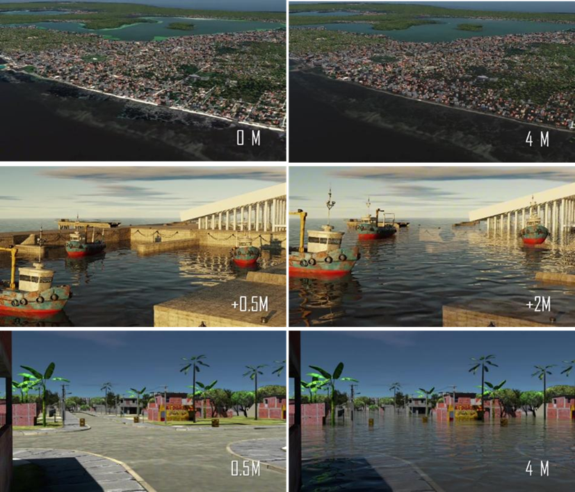
Digital Twin Deployment: A 3D digital twin of Tongatapu was created using 30cm-resolution satellite imagery, deep learning-based building detection, and NeRF/Gaussian Splatting. The digital twin allowed simulation of sea-level rise and flood scenarios for risk visualization and policy planning.
Impact
The integrated disaster platform is provided by the project team, along with valuable insights to support decision-making processes. For instance, the NDRMO and/or technical staff related to Remote Sensing and GIS have acquired knowledge from the project team to better understand the EO technologies and their applications and to appropriately monitor the land surface or changes in the context of preparedness for disaster, such as drought, land subsidence, landslide, sea level rise, and flooding. Plus, the capacity building workshop was conducted in December 2024 by inviting not only people living in Tonga islands, but also people working in other countries and regions. Through this workshop and process, the connection and knowledge sharing between technical staff has been accelerated.
Stakeholders
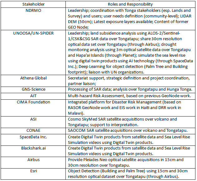
This project emphasizes collaboration with multi stakeholders, including UN agencies, national governments, space agencies, local governments, private space companies, and research institutions. The role of each stakeholder is as shown below.