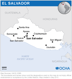
UN-SPIDER assembled a team of experts from Latin America who focus their work on the use of satellite applications for various activities including disaster risk reduction, preparedness and emergency response.
- Mr. Luc St-Pierre, Coordinator of the UN-SPIDER Programme
- Mr. Juan Carlos Villagran de Leon, UN-SPIDER
- Mrs. Silvia Pardi Lacruz, National Institute of Space Research of Brazil, INPE
- Mrs. Stella Navone, Faculty of Agriculture, University of Buenos Aires, Argentina
- Mr. Sergio Camacho, Regional Centre for Space Science and Technology Education for Latin America and the Caribbean, CRECTEALC
- Mr. Marcelo Oyuela, Water Center for the Humid Tropics of Latin America and the Caribbean, CATHALAC
- Mr. Hector Mauricio Ramirez, Agustin Codazzi Geographic Institute, Colombia, IGAC.
The mission team benefited from the support of Mrs. Blanca de Aviles and Mr. Raul Murillo of the General Directorate for Civil Protection.
The mission included meetings with staff of the two host institutions: the Secretariat for Vulnerability Issues and the General Directorate for Civil Protection; as well as with representatives of the Ministries of Environment and Natural Resources; Agriculture and Livestock; Public Works, Transport, Housing and Urban Development; Foreign Affairs; Public Health and other government agencies, regional and international organizations and the University of El Salvador. The mission included a review of existing legislation and policies targeting disaster risk management, emergency response and sustainable development as well as institutional web pages and other documents from these and other relevant institutions.
The mission analyzed five aspects that are relevant to the generation and use of information derived from satellite applications in all phases of the disaster management cycle: Satellite imagery processing and visualization of geospatial information; Applications of geospatial information in all phases of the disaster management cycle; Access to and exchange of data, information and satellite images among government agencies; Inter-institutional networks; Capacity building and institutional strengthening.
The mission team developed a set of recommendations that aim to improve existing capabilities in terms of access, processing, generation and use of space-based information during all phases of the disaster management cycle.
The mission team noted the high relevance assigned by the government and the Presidency of the Republic to the topics of disaster risk reduction, preparedness, response and recovery. These issues are addressed explicitly in the 2010-2014 National Development Plan, which outlines the policies and efforts to be conducted by the government as a way to reduce the effects of hazards of natural origin throughout the country. The mission team also took note of the efforts which are being conducted by Ministries and other government agencies, as well as universities in El Salvador, as a way to manage existing risks and to respond in case of disasters; and of the notion of inter-institutional efforts which are contemplated in the National Plan for Civil Protection, Prevention and Mitigation of Disasters of El Salvador.
The mission team also identified several institutions that have a good knowledge of data and products derived from satellite applications, among them the Environmental Observatory of the Ministry of Environment and Natural Resources and the Geographic Institute. Additionally, several government organizations have made use of Geographic Information Systems (GIS) to generate maps focusing on various types of content. In the context of natural hazards, satellite-imagery has been used to generate flood hazard maps and in case of disasters. The mission team took note of the fact that the Environmental Observatory is aware of the International Charter – Space and Major Disasters but is somewhat critical about the use of the product generated by this emergency mechanism set up by the space community.
Furthermore, the team noted that at present, the exchange of data and information among institutions is mostly done on a bilateral basis as compared to a multilateral approach. In order to enhance the use of geospatial data within government ministries and agencies, the Geographic Institute is currently promoting the National Geospatial Data Policy with the goal of establishing a Spatial Data Infrastructure for El Salvador (SDI-ES). This SDI-ES aims to facilitate access to and exchange of data among many institutions.
Based on their observations, the team of experts proposed a number of recommendations that aim to institutionalize the generation and use of space-based information during all phases of the disaster management cycle. The most important recommendation is the implementation of a policy by the National System of Civil Protection, Disaster Prevention and Mitigation and the General Directorate for Civil Protection focusing on the generation and use of geospatial information for decision-making in regard to integrated disaster risk management, response and recovery.
As proposed strategies to implement this policy, the experts suggested:
- The establishment of an Integrated Geospatial Information System
- The promotion of an inter-institutional approach to leverage existing capabilities in various ministries and government institutions, as well as in universities and private sector institutions
- The utilization of opportunities offered by the space community in terms of data, images and products that are available free of charge to generate relevant and pertinent information
The experts also highlighted the need to strengthen the capacities of staff in government agencies and other institutions which are responsible for disaster risk management and emergency response on the generation and use of space-based information through short term courses.

