Multiple earthquakes, with the strongest two measuring 5.7 and 5.6 on the Richter scale, struck the mountainous rural regions of Yunnan and Guizhou, in the Yiliang and Weining counties in southwest China on Friday 7 September 2012, killing at least 80 people and injuring more than 160 others. As a result of the earthquakes in this mountainous area, landslides have also been experienced. The most serious damage was in Yiliang county, where the majority of the fatalities occurred. An estimated 100,000 people have been evacuated and approximately 20,000 houses were destroyed. The mountainous terrain in the region is making relief efforts to remote locations difficult.
Upon request from the National Disaster Reduction Centre of China (NDRCC), UNOOSA/UN-SPIDER immediately placed a request to the National Remote Sensing Centre (NRSC) of Indian Space Research Organisation (ISRO) and DigitalGlobe to task high resolution satellite imagery collection of the earthquake-hit area. The prompt action of UN-SPIDER helped ISRO and DigitalGlobe to plan tasking on the same day (7th September 2012) and collect the images on the following day, 8th September 2012.
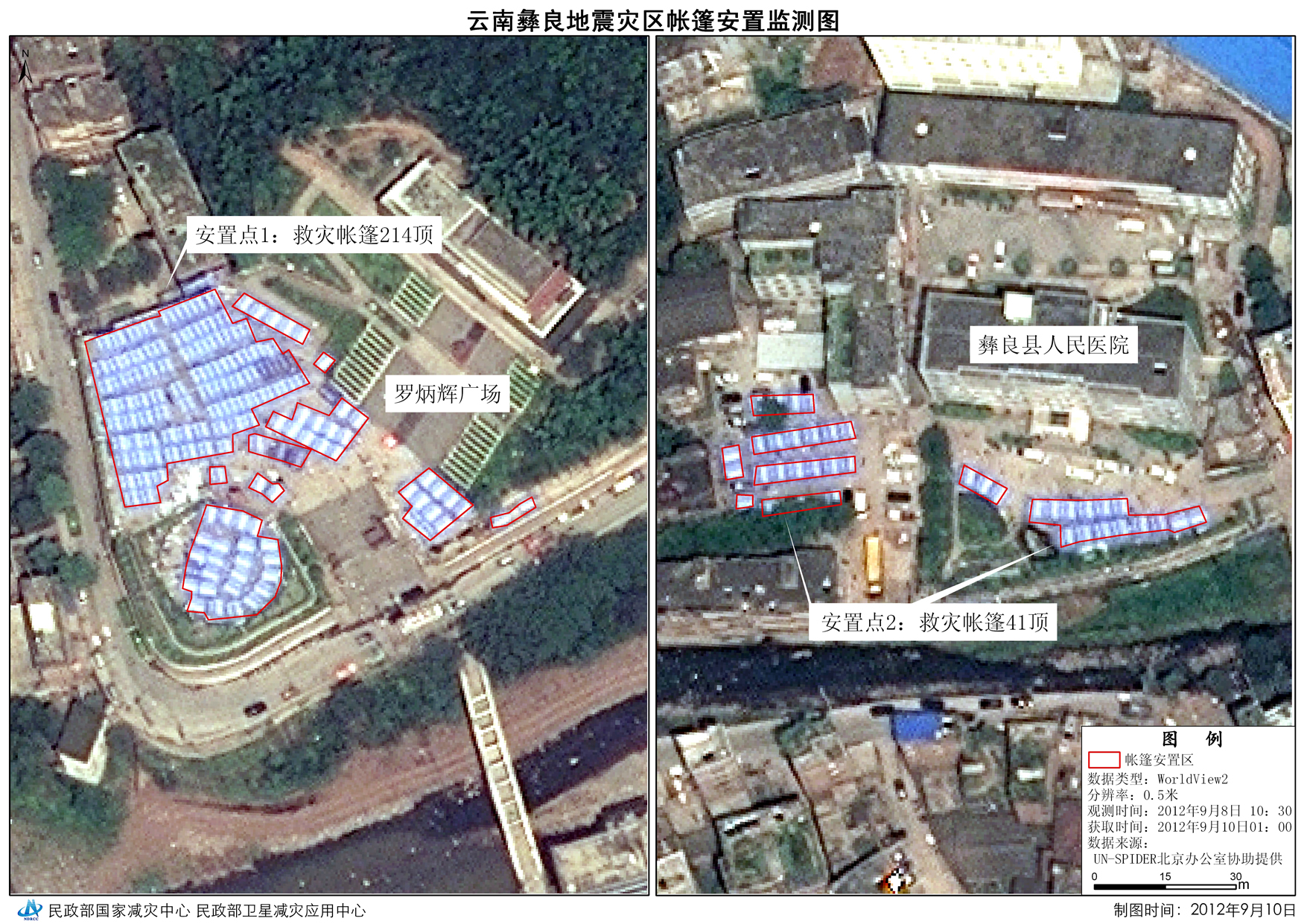
A total of 56 images were provided to China through UN-SPIDER's request on day after the event to assess the impact of the earthquake. Of 56 images, 12 were pre-disaster and 44 were post-disaster images. NRSC/ISRO images were uploaded through the UN-SPIDER and NRSC FTP servers. Additionally, DigitalGlobe created a Cloud Services (DGCS) evaluation account for UNOOSA/UN-SPIDER to provide access to pre and post-earthquake images.
NDRCC staff is on 24 hours duty to utilize these satellite images to assess impact of earthquake. Furthermore, the International Charter: Space and Major Disasters was activated on Friday 7 September 2012 for the region of Yunnan Province and Weining County, Guizhou Province. The Charter was activated by the National Disaster Reduction Center of China (NDRCC).
| Satellite/Sensor | Date of Acquisition | Number of Scenes | Data Source | Download date and time | Download channel |
| IRS Cartosat-1 | 8 September 2012 | 9 | National Remote Sensing Centre (NRSC), ISRO | 9 September 2012, 8 a.m. | UN-SPIDER FTP |
| IRS P5 | 8 September 2012 | 6 | National Remote Sensing Centre (NRSC), ISRO | 10 September 2012, 5:30 p.m. | NRSC/ISRO FTP |
IRS Cartosat-2 | 8 September 2012 | 7 | National Remote Sensing Centre (NRSC), ISRO | 10 September 2012, 10:30 p.m. | UN-SPIDER FTP |
| Worldview | 8 September 2012 | 22 | Digital Globe | 9 September 2012, 9 p.m. | Digital Globe FTP |
| Worldview | 19 February 2010 | 12 | Digital Globe | 10 September 2012, 4 p.m. | Digital Globe FTP |
| Attachment | Size |
|---|---|
| ThematicMaps1.jpg | 1.65 MB |
| ThematicMaps2.jpg | 1.72 MB |
| ThematicMaps3.jpg | 4.62 MB |
| ThematicMaps4.jpg | 4.6 MB |
| ThematicMaps5.jpg | 1.91 MB |
| ThematicMaps6.jpg | 1.91 MB |