, processed by ESA.")
Space technologies and geospatial data can support governments in improving situational awareness and responding to the COVID-19 outbreak. Several institutions have published information products, such as web maps of confirmed infections and deaths, that are making use of the advantages of GIS. Others have used space technologies to track pollution levels across the world, highlighting a drop due to the restrictions imposed as a result of the pandemic. Yet others are using a combination of global navigation satellite systems technologies to map the position of critical infrastructure in geographical areas where there are reported cases.

The United Nations Office for Outer Space Affairs, through its UN-SPIDER programme, has created this COVID-19 emergency response overview page to facilitate the discovery of examples of contributions of space technologies to addressing COVID-19 that are being published by government agencies, international and regional organizations, academia, civil society and the private sector. To find out more about the efforts of UNOOSA in advancing the use of space-based solutions for global health, please visit this web page.
To support users in finding relevant content, the list below can be filtered by keywords as well as format of the resource. The list does not seek to be exhaustive, nor to recommend particular sources, but to provide a selection of examples of how space technologies and the space community support response efforts to COVID-19.
UNOOSA will host a webinar on Space4Health on 14 May at 10am and 4pm Vienna, Austria time (UTC+2).
If you are using space technologies for responding to the COVID-19 pandemic and would like your work to be included on this page, please use this form to submit details.
International collaboration among space agencies is central to the success of satellite Earth observations and data analysis. These partnerships foster more comprehensive measurements, robust datasets, and cost-effective missions.
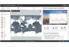
The tri-agency COVID-19 Dashboard is a concerted effort between the European Space Agency (ESA), Japan… Read more
, Web page
Tag: (Indirect) impact of the virus
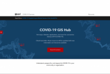
On the COVID-19 GIS Hub, ESRI provides maps, datasets, applications, and more to support users in responding to COVID-19. The materials are updated with new information as it becomes available.
The page also features a link to the ArcGIS COVID-19 Application Index (System of Systems), which provides an overview of dashboards created… Read more
Tag: Situational data, Risk assessments, Emergency mapping
With its 30+ EU-owned satellites, the EU Space Programme, notably through its Earth observation component, Copernicus, and its satellite navigation system, Galileo, offers free and open data information that can help monitor and potentially mitigate the impact against the coronavirus outbreak. On this page, users will find a list of select… Read more
Tag: Situational data, Risk assessments, Emergency mapping, (Indirect) impact of the virus, Research opportunities
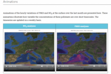
The Copernicus Atmosphere Monitoring Service (CAMS) is continually monitoring air quality in Europe and around the world using satellite and ground-based observations and advanced numerical models. The page provides access to graphical products and animations, as well as some answers to questions related to CAMS products and their… Read more
, Web page
Tag: (Indirect) impact of the virus

The OpenQuake Map Viewer has released a map that indicates areas where an earthquake could cause increases in COVID-19 cases due to displacement of people from damaged buildings or where health care systems may be further stressed due to human injuries. The map uses COVID-19 statistics released by Johns Hopkins University Coronavirus Resource… Read more
, Web page
Tag: Situational data, Risk assessments
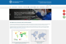
This open-access tool developed by the Food and Agriculture Organization of the United Nations (FAO) Data Lab gathers and analyses real time information on the impact of the COVID-19 pandemic on food and agriculture, value chains, food prices, food security and undertaken measures, with the aim of providing countries with facts and information… Read more
Tag: Situational data, (Indirect) impact of the virus, UN activities
The European GNSS Agency (GSA) in collaboration with the European Commission has developed a mobile solution, the “Galileo Green Lane” App, to facilitate the free movement of freight, reduce waiting times at EU borders, and prioritize essential goods during the current COVID-19 pandemic response.The app uses the… Read more
Tag: Emergency mapping, (Indirect) impact of the virus

As European governments plan their phased recoveries from the lockdown states triggered by the COVID-19 pandemic, the positioning delivered through satellite navigation is becoming more important than ever before. Location is a key requirement when attempting to monitor and map the spread of a disease and satnav is one of the main tools… Read more
Tag: Emergency mapping

The GEO Health Community of Practice (CoP) has activated the global EO4Health community to coordinate responses to COVID-19. The GEO Health CoP is organizing a series of weekly teleconferences that provide an opportunity to share research applications and related activities that use Earth observations to advance knowledge on COVID-19… Read more
Tag: Research opportunities

GEO has announced the GEO Indigenous COVID-19 Hackathon 2020, a project that involves developing a series of virtual hackathons in various Indigenous and under-represented communities with the intent of co-designing locally relevant EO-based challenges that are… Read more
Tag: Situational data, (Indirect) impact of the virus, Research opportunities

GEOGLAM aims at increasing market transparency and improving food security by producing timely and actionable information on agricultural conditions and outlooks of production at national, regional, and global scales. To face the challenges that the COVID-19 pandemic has brought, GEOGLAM has been providing monthly global Crop Monitors… Read more
Tag: (Indirect) impact of the virus

The media outlet Geospatial World has created a page that brings together information about all major dashboards and apps related to COVID-19, along with news articles and analytics pieces on how geospatial data and technologies are helping in combatting and containing the Coronavirus.
Tag: Situational data, Risk assessments, Emergency mapping, (Indirect) impact of the virus