, processed by ESA.")
Space technologies and geospatial data can support governments in improving situational awareness and responding to the COVID-19 outbreak. Several institutions have published information products, such as web maps of confirmed infections and deaths, that are making use of the advantages of GIS. Others have used space technologies to track pollution levels across the world, highlighting a drop due to the restrictions imposed as a result of the pandemic. Yet others are using a combination of global navigation satellite systems technologies to map the position of critical infrastructure in geographical areas where there are reported cases.

The United Nations Office for Outer Space Affairs, through its UN-SPIDER programme, has created this COVID-19 emergency response overview page to facilitate the discovery of examples of contributions of space technologies to addressing COVID-19 that are being published by government agencies, international and regional organizations, academia, civil society and the private sector. To find out more about the efforts of UNOOSA in advancing the use of space-based solutions for global health, please visit this web page.
To support users in finding relevant content, the list below can be filtered by keywords as well as format of the resource. The list does not seek to be exhaustive, nor to recommend particular sources, but to provide a selection of examples of how space technologies and the space community support response efforts to COVID-19.
UNOOSA will host a webinar on Space4Health on 14 May at 10am and 4pm Vienna, Austria time (UTC+2).
If you are using space technologies for responding to the COVID-19 pandemic and would like your work to be included on this page, please use this form to submit details.
Since the outbreak of the coronavirus earlier this year, a number of apps have been developed that use Global Navigation Satellite Systems (GNSS) precise location to monitor the global spread of the virus. The European GNSS Agency (GSA) is maintaining a list of location-GNSS-Galileo based applications that, in GSA’s view, may be useful in… Read more
Tag: Situational data
In the last few weeks, the COVID-19 virus outbreak has gone global and poses a serious threat to world’s health. Therefore, GSA is looking for solutions using downstream space data (e.g. Galileo/EGNOS and/or Copernicus) as key enablers to develop innovative applications that will help stem the spread of the novel COVID-19 virus.
Tag: (Indirect) impact of the virus
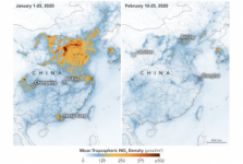
Using mostly space-based information, NASA explains the impact of COVID-19 on pollution, traffic and coal consumption. It also highlights and rectifies misinformation that was circulating on social media, such as that elevated levels of sulfur dioxide (SO2) were allegedly due to an increase in human cremation.
Tag: (Indirect) impact of the virus
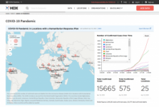
The Humanitarian Data Exchange COVID-19 crisis page provides an overview of the spread of COVID-19 in locations with a Humanitarian Response Plan in place. It also lists relevant datasets from various institutions, which can be easily accessed through the HDX platform.
, Map
, Web page
Tag: Situational data, Risk assessments, Emergency mapping, (Indirect) impact of the virus, UN activities
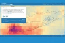
As the world rushes to contain the COVID-19 coronavirus, tracking where and how it’s spreading is difficult due to the global nature of society. This webinar from Maxar demonstrates how geospatial data is essential for pandemic modeling, helping organizations plan and activate more effective response.
DigitalGlobe, a Maxar… Read more
Tag: Situational data, Risk assessments, Emergency mapping

The paper presents how satellite data could provide insights on the impact of confinement measures implemented by governments across the world and identify some ways satellite data could be used to quantify the industrial and environmental impact of the Covid-19 crisis.
Tag: (Indirect) impact of the virus

Earth observation satellites of the Japan Aerospace Exploration Agency (JAXA) are monitoring the Earth's surface to detect the changes in the global environment and human society related to COVID-19.
The "JAXA for Earth on COVID-19" site introduces the latest observation and analysis results. It provides an overview about… Read more
Tag: Situational data
To accelerate the world’s response to COVID-19, XPRIZE is launching the XPRIZE Pandemic Alliance, powered by the XPRIZE Data Collaborative, a powerful platform for collaboration, combining data, AI tools, and bleeding edge insights and ideas with a community of innovators on the fringe. Their first priority is to bring visibility… Read more
Tag: Research opportunities
ESA is organizing a live streamed conversation with European experts on how space can help with post-millennials’ education and social lives. Guests will discuss how national education systems have responded to online schooling, access to communications tools for students, the importance of the social component in the learning… Read more
Tag: (Indirect) impact of the virus
The National Aeronautics and Space Administration's (NASA) continuous and sometimes near-real-time measurements of Earth allow for understanding both the systems changes themselves and the potential impact on economies and society during the pandemic – and as the world slowly returns to operations.… Read more
Tag: (Indirect) impact of the virus

Nasa has been funding four research projects that investigate COVID-19 impacts. The first project from George Washington University will shed light on why there are inconsistent effects of COVID-19 lockdowns on air quality in different cities by analysing weather, traffic counts and other data. The second research from the University at Buffalo… Read more
Tag: Situational data, (Indirect) impact of the virus, Research opportunities
Scientists are using information from NASA’s Earth-observing satellites, on-the-ground sensors and computer-based datasets to study the environmental, economic and societal impacts of the COVID-19 pandemic. In addition, the agency’s Earth Science Division recently sponsored new projects to examine how the shutdowns in response to… Read more
Tag: (Indirect) impact of the virus