Using GloFAS for Early Warning of Riverine Flood Events – A Case Study for Nigeria
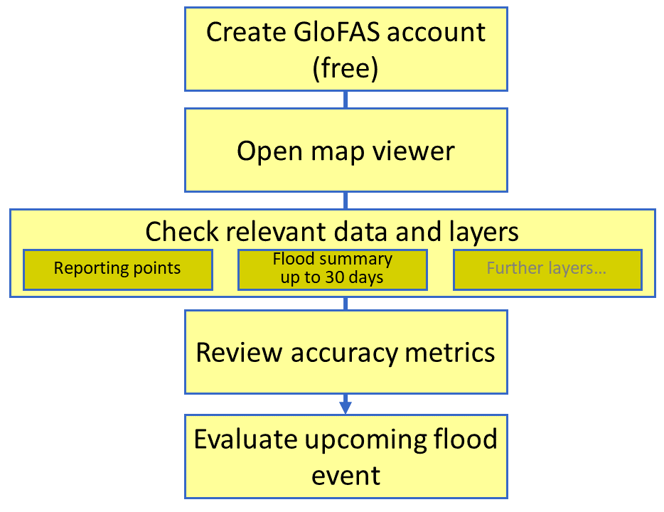
The Global Flood Awareness System (GloFAS) is part of the Copernicus Emergency Management Service (CEMS) and provides operational, extended-range ensemble flood forecasts with a 30-day lead-time for major river basins based on hydrological and meteorological data with a global coverage.
Through its products, GloFAS provides early warning information that can be used by response groups such as national disaster management agencies and humanitarian organizations to prepare for a flood event. Besides ascertaining whether a flood could occur, GloFAS’s return period exceedance metrics give insights into the potential magnitude of a flood, which is vital in estimating the level of impact. Subsequently, government agencies can quantify the resources required for emergency response and mitigation. Further, impact aggregated over administrative regions can provide a hint about areas of priority and specifically alert the local authorities to put mitigation measures in place. This case study shows the application of GloFAS during a severe flood event in Nigeria in 2022 for early warning.
This case study intends to illustrate how various products available within the Copernicus’s Global Flood Awareness System (GloFAS) platform can be utilized within the disaster management cycle phases using a recent example of the Nigeria floods of 2022 that occurred along the Benue and Niger rivers and their confluence.
Early warning capacities can be limited in many parts of the world. Copernicus, part of the European Union Space Programme, offers free tools and services to bridge the gap and make early warning information accessible globally. The Global Flood Awareness System, GloFAS, is part of the Copernicus Emergency Management Service’s “Early Warning & Monitoring” portfolio, which also includes the Global Drought Observatory (GDO) as well as the Global Wildfire Information Service (GWIS).
GloFAS can be used for flood early warning globally. However, data accuracy will vary between regions based on factors such density of local measurement networks and area of the river-basin.
Neither UN-SPIDER nor the Regional Support Offices (RSOs) or their partners take any responsibility for the correctness of outputs from this practical use or decisions derived as a consequence.