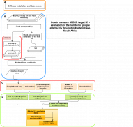
The objective of this practice is to showcase how the combination of remote sensing and statistical data can be used to inform selected SFDRR indicators. The technical guidance by UNDRR provides support for the Member States in the operationalization of the indicators to measure progress towards the achievement of the targets of the SFDRR.
In order to calculate Sendai indicator B5 (Number of people whose livelihoods were disrupted or destroyed, attributed to disasters) the following sub-indicators and methodology are proposed for measuring the number of people whose activities required for securing a means of living or as their source of income has been affected:
- B5a: Number of workers in agriculture with crops damaged or destroyed by disasters (estimated using sub-indicator C-2Ca, described in the Technical Guidance for Target C).
- B5b: Number of workers responsible for, and owners of livestock lost attributed to disasters (estimated using sub-indicator C-2La).
- B5c: Number of workers employed in productive assets facilities (such as Industrial, commercial, services, etc.) damaged or destroyed by disasters.
The technical note on data and methodology to estimate the number of affected people is adjusted to the Eastern Cape and drought context. Only indicators B5a and B5b are considered. Hence, Parts A and B focus on the drought hazard assessment whereas Parts C and D focus on the indicator measurement by combining the drought hazard with information on land-use, as well as agricultural statistics and census data to estimate the number of people affected by drought.
The Eastern Cape gets gradually wetter from west to east. The west is mostly semiarid karoo, except in the far south, which is temperate rainforest in the Tsitsikamma region. The east is grassland on hills, interrupted by deep gorges with intermittent forest.
The agricultural system in Eastern Cape is divided into commercial and communal farming: in contrast to the mainly small-scale communal (subsistence) farming stands the large-scale commercial farming (of mainly white farmers), which usually comprises technologically more advanced agriculture on farms larger than 1000ha. Communal farming is mainly found in the Eastern parts of the province.
The processing chain was developed for the South African context which makes it most applicable for this setting. Depending on (1) the cloud cover, part A and B could also be adjusted to be used in other contexts and depending on (2) data availability, part C and B could be reproduced in another context as well.
Bibliography
Walz, Yvonne, Annika Min, Karen Dall, Moses Duguru, Juan-Carlos Villagran de Leon, Valerie Graw, Olena Dubovyk, Zita Sebesvari, Andries Jordaan, and Joachim Post. “Monitoring Progress of the Sendai Framework Using a Geospatial Model: The Example of People Affected by Agricultural Droughts in Eastern Cape, South Africa.” Progress in Disaster Science, 5 (January 1, 2020): 100062. https://www.sciencedirect.com/science/article/pii/S2590061719300626?via%3Dihub


