Recommended Practice: Land Cover Change Detection through Supervised Classification
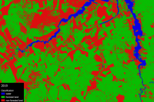
This Recommended Practice aims to (1) conduct a supervised land cover classification in QGIS using the SCP plugin and (2) to conduct change detection analysis. These skills are applicable to a vast range of disasters throughout the entire disaster management cycle. In this example, the remote sensing technique is applied to monitor deforestation in a part of the Amazon rainforest south of Santarém, Pará, in Brazil. However, it can be applied to any other study area. The required inputs are two or more satellite images of the same area at a different point in time. This will result in an output of a table showing the exact change in land cover in number of pixels as well as a visualization of the land cover change in the form of a shapefile.
This practice was applied to the Amazon rainforest south of Santarém, Pará, in Brazil between 2015 and 2019 to monitor rainforest deforrestation in that period.
This method can be applied to any other area of study in which change detection from one landcover type to another is desired.
Neither UN-SPIDER nor the Regional Support Offices (RSOs) or their partners take any responsibility for the correctness of outputs from this recommended practice or decisions derived as a consequence.