  • English
  • Español
  • Français

United
Nations


Office for Outer Space Affairs
UN-SPIDER Knowledge Portal

  • Inicio
  • Sobre nosotros
    • Sobre ONU-SPIDER
    • Acerca de UNOOSA
    • Publicaciones
    • Ofertas de trabajo
    • Conozca el Equipo
    • Contacto
  • Aplicación Espacial
    • Guías Tecnológicas
    • Mecanismos de Emergencia
    • Mecanismos de Recuperación
    • Red Internacional de Alerta de Asteroides
    • Grupo Asesor para la Planificación de Misiones Espaciales
    • Iniciativa Internacional sobre Meteorología Espacial
    • Tecnologías Espaciales en la ONU
    • Historias de Usuarios
  • Enlaces y Recursos
    • Aplicación de datos del mes
      • Disaster Recovery
    • Fuentes de Datos
    • SIG y Software de Percepción Remota
    • Recursos de capacitación en línea
    • Instituciones
  • Riesgos y Desastres
    • Gestión del Riesgo de Desastres
    • Alerta temprana
    • Gestión de Desastres y Emergencias
    • Amenazas Naturales
    • El Proceso de la Reducción de Desastres Post-2015
    • La ONU y la Gestión del Riesgo de Desastres
    • La ONU y Alerta Temprana
    • La ONU y la Gestión de Desastres
  • Asesoría
    • Misiones de Asesoría
    • Apoyo en caso de Emergencia
    • Asesoría Virtual
    • Prácticas Recomendadas
    • Actividades de Entrenamiento
    • Usos Prácticos
  • Redes
    • Oficinas Regionales de Apoyo
    • GP-STAR
    • IN-MHEWS
    • IWG-SEM
  • Proyectos
    • SPEAR
    • FOSAT-S
    • EvIDENz
    • Flood GUIDE
    • CommonSpace Initiative
    • Tonga Pilot Project
  • Noticias y Eventos
    • Noticias
    • Eventos
    • Eventos pasados

Breadcrumb

  • Home
  • Recommended Practice: Land Cover Change Detection Through Supervised Classification
  • Recommended Practice: Land Cover Change Detection through Supervised Classification

Recommended Practice: Land Cover Change Detection through Supervised Classification

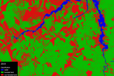
This Recommended Practice aims to (1) conduct a supervised land cover classification in QGIS using the SCP plugin and (2) to conduct change detection analysis. These skills are applicable to a vast range of disasters throughout the entire disaster management cycle. In this example, the remote sensing technique is applied to monitor deforestation in a part of the Amazon rainforest south of Santarém, Pará, in Brazil. However, it can be applied to any other study area. The required inputs are two or more satellite images of the same area at a different point in time. This will result in an output of a table showing the exact change in land cover in number of pixels as well as a visualization of the land cover change in the form of a shapefile.

/advisory-support/recommended-practices/recommended-practice-land-cover-change/…
Forest Fire
Mitigation
Preparedness
Recovery & Reconstruction
Relief & Response
Brazil

This practice was applied to the Amazon rainforest south of Santarém, Pará, in Brazil between 2015 and 2019 to monitor rainforest deforrestation in that period.

This method can be applied to any other area of study in which change detection from one landcover type to another is desired.

Datos relacionados

view all

Software relacionado

view all

Descargo de responsabilidad:

Por favor tome nota que ni ONU-SPIDER ni las Oficinas Regionales de Apoyo o sus socios se responsabilizan por la calidad de los resultados que se obtienen usando esta práctica recomendad o las decisiones que se tomen con estos resultados.


Footer menu

  • Contact
  • Terms of Use

User account menu

  • Log in