![]()
United
Nations
Tsunami
 and the Ohio State University (OSU) used satellite altimeters to observe “merging tsunamis”. The image comes from a data-based computer model that shows Tohoku-oki tsunami waves propagation. Waves peaks are depicted in red-brown, while depressions in sea surface appear in blue-green. Grayscale outlines show the location of mid-ocean ridges, peaks, and islands. Image: NASA.")
Definition
Facts and figures
Further information
UN-SPIDER Regional Support Offices with hazard-specific expertise
Related content on the Knowledge Portal
 The Copernicus DEM is a Digital Surface Model (DSM) which represents the surface of the Earth including buildings, infrastructure, and vegetation. The Copernicus DEM is provided in 3 different instances. Two worldwide coverages at 90m (GLO-90) and 30m (GLO-30) resolution are openly available to the public for download via the PANDA Catalogue and FTP. A further European coverage (EEA-10) is provided at 10m resolution, but data is restricted to eligible users who meet required access rights.Publishing institution:
 Publishing institution:
 The Copernicus Open Access Hub provides complete, free and open access to Sentinel missions data.Publishing institution:
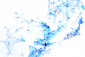 Facebook Connectivity Lab in collaboration with the Center for International Earth Science Information Network (CIESIN) at Colombia University combines machine vision AI with satellite imagery and census information to create population density maps. With the integration of demographic information, specifically related to age and gender, these maps collectively provide information on both the location and the demographic of a population in a certain country. The population density maps cover the majority of countries around the world.Publishing institution:
-
Facebook Connectivity Lab in collaboration with the Center for International Earth Science Information Network (CIESIN) at Colombia University combines machine vision AI with satellite imagery and census information to create population density maps. With the integration of demographic information, specifically related to age and gender, these maps collectively provide information on both the location and the demographic of a population in a certain country. The population density maps cover the majority of countries around the world.Publishing institution:

Having reliable and timely population distribution data can make a life or death difference for individuals facing crises or living in conflict-ridden regions. These data are also essential for development decision-making and planning and for monitoring progress towards the UN Sustainable Development Goals (SDGs) established by the international community. We need to know where people are located, what conditions they are facing, what infrastructure is available, and what basic services they can access. We also need to ensure that no one is left off the map in pursuit of meeting the SDGs.
Gridded population data, which often use remote sensing inputs to improve the spatial allocation of population within a country, are vital for all these purposes. Together with the growing variety of applications that require spatial population data, there is now a bewildering array of population grids, and users need to know which ones are most suitable for their applications...
read more
The United Nations Office for Outer Space Affairs (UNOOSA) and the National Aeronautics and Space Administration of the United States Government (NASA) signed a landmark Memorandum of Understanding (MoU) on 17 December 2020 pledging cooperation in areas of science and technology to support the peaceful uses of outer space.
The MoU brings together NASA's wealth of open-source spacecraft data, tools, and expertise and UNOOSA's unique position as the only UN entity dedicated to outer space affairs, to expand global opportunities to leverage the benefits of space. The partners will design capacity-building programmes, particularly for institutions in countries that do not yet have or that are developing space capabilities, to help them access space.
Together, UNOOSA and NASA will develop ways to leverage the Artemis programme as part of UNOOSA's Access to Space 4 All Initiative, which offers opportunities for international researchers and institutions, especially in...
read more11/01/2021
The European Commission plans to rapidly expand its environmental monitoring programme Copernicus. For this purpose, the European Space Agency (ESA) recently pledged 2.55 billion Euros towards contracts to advance the production of six new Copernicus satellite missions. The final of the six contracts was signed last Thursday between ESA and Thales Alenia Space for a mission that will provide new and important information to climate research and disaster management.
The high-priority Copernicus Radar Observation System for Europe in L-band (ROSE-L) mission is planned to launch in 2028 for a period of 7.5 years. The ROSE-L mission will orbit Earth every few days at an altitude of 690km and will carry a L-Band synthetic aperture radar (SAR). With a wavelength of approximately 23cm, an...
read more18/12/2020
The Disasters programme unit at the National Aeronautics and Space Administration (NASA) recently joined a newly launched online platform aimed at placing anticipatory action on the humanitarian agenda. NASA’s involvement in the Anticipation Hub and the subsequent incorporation of Earth observation (EO) tools, serves to improve the capabilities of anticipatory action globally and demonstrates the potential of utilizing satellite-driven data for anticipatory action in disaster management.
Anticipatory action in the humanitarian context describes disaster mitigation activities based on in-depth forecast information and risk analysis. This approach has gained traction amongst the humanitarian community in recent years as it is viewed as a more efficient and affordable alternative to...
read more02/02/2021 of the European Commission.")
A new report outlines the impact of Global Human Settlement Layer (GHSL) data on various policy areas. The 2020 edition of the “Atlas of the Human Planet”, recently published and launched virtually by the Joint Research Centre (JRC) of the European Commission as a deliverable to the Group on Earth Observations (GEO) Human Planet Initiative, explores the impact of GHSL data on various policy areas, including disaster risk management.
GHSL data refers to “global spatial information, evidence-based analytics and knowledge describing the human presence on the planet”. This data relies on spatial information from Landsat 8, Sentinel-1 and Sentinel-2. It is mainly cost-free and...
read more18/02/2021
Term Parents
UN-SPIDER Regional Support Offices with hazard-specific expertise
![]()