Copernicus DEM (GLO-30 & GLO-90)

| Data provided by: | European Space Agency (ESA), Airbus Defence & Space |
| Data accessibility: | export data |
| Link to the data: | |
| Requirements: | Registration at the Copernicus Space Component Data Access (CSCDA) web portal. |
| File type: | GeoTIFF |
| Data type: | elevation |
| Hazard: | Biological, Climatological, Forest Fire, Drought, Glacial Lake Outburst, Geophysical, Mass Movement, Subsidence, Earthquake, Tsunami, Volcanic Eruption, Hydrological, Flood, Landslide, Meteorological |
| Disaster cycle phase: | Disaster Risk Management, Response, Recovery |
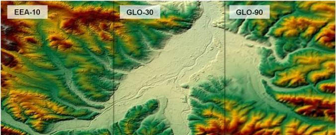
| Space-based Information: | The Copernicus DEM is a Digital Surface Model (DSM) which represents the surface of the Earth including buildings, infrastructure, and vegetation. The Copernicus DEM is provided in 3 different instances. Two worldwide coverages at 90m (GLO-90) and 30m (GLO-30) resolution are openly available to the public for download via the PANDA Catalogue and FTP. A further European coverage (EEA-10) is provided at 10m resolution, but data is restricted to eligible users who meet required access rights. |
| Spatial coverage: | Global |
| Spatial resolution: | 10m, 30m, 90m |
| Temporal coverage: | Archive |
| Technical Specifications: | |
| Costs: | free |
| Tutorials on the use of data: | CSCDA User Registration Video Tutorial, How to Access Copernicus DEM via the PANDA Catalogue Video Tutorial, How to Access Copernicus DEM via FTP Video Tutorial |
| Restrictions/ Citation of the dataset: | Copernicus User Access Rights and User Licence. |

