A new publication presents 30 innovation products and approaches for disaster risk reduction, ranging from GIS and remote sensing to community-based disaster risk reduction and indigenous DRR technology. “30 Innovations for DRR” has been published by a group of experts from Keio University, the University of Tokyo, the United Nations University, CWS Japan and IRIDeS of Tohoku University. The collection is the result of a meeting organized by the Association of Pacific Rim Universities (APRU) Multi-Hazards Program at which participants agreed to work to scientific research results relevant to practitioners more accessible and curate products and approaches based on science and technology considered to be effective and innovative.
The Sendai Framework for Disaster Risk Reduction encourages better access and support for innovation and technology as well as increased investment in DRR to develop new innovations that are both cost-effective and beneficial when applied in all disaster management phases. It also calls for the promotion of scientific research and to support the “availability and application of science and technology to decision making.
Parallel to the publication, a survey was conducted to determine the innovations for DRR considered to be the most effective among academia, NGOs, international organizations, governments, and the private sector. Of special interest to many, of the ten innovations selected most frequently, five are products and six are approaches (two received the same score). These results show that products and approaches are equally recognized as innovations and that they both contribute to improving existing and traditional DRR efforts for tackling new challenges.
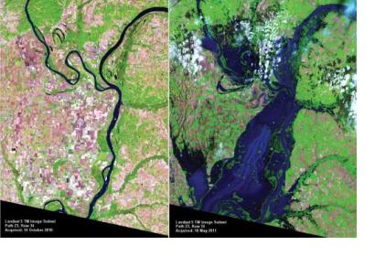
Between the innovative products showcased in the report, there is also the application of GIS and remote sensing in disaster risk reduction.
The report highlights how the combination of GIS and remote sensing has drastically changed the concept of mapping and spatial interpretation of risk and resources.
GIS is now the very basic information system for any disaster-related database at the local, national and regional level and this has changed the concept of mapping. Remote sensing images are used for interpretation of resources as well as risks and can be used for effective pre-disaster mitigation measures. With current high precision remote sensing data, especially using high precision satellite images, the urban diagnosis has become easier as well as effective. Also, before after remote sensing images help to understand the extent of damages immediately after a disaster.

