![]()
United
Nations
Feu de forêt
, processed by ESA, CC BY-SA 3.0 IGO.")
Definition
Facts and figures
Further information
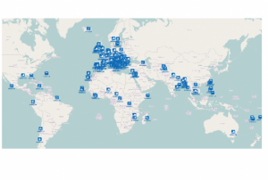
UN-SPIDER Regional Support Offices with hazard-specific expertise
Related content on the Knowledge Portal
 ,
,  ,
,  ,
, 
Developed for the needs of the ASEAN sub-region in Asia and the Pacific, the handbooks can also be adapted for use in other regions.
The handbooks have been developed through expert working groups, in collaboration with United Nations partners including UNOOSA/UN-SPIDER, UNITAR-UNOSAT, and OCHA. As well as extensive consultation with space agencies, national disaster management authorities and regional institutions, including GISTDA, LAPAN, ASEAN Coordinating Centre for Humanitarian Assistance on Disaster Management and Asian Institute of Technology.
read morePublishing institution: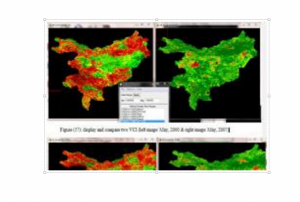 ,
, 
Vegetation Condition Index according to Kogan et al. (1990). Two-weeks normalized Differenced Vegetation Index (NDVI) composites based on 250m MODIS data are freely available for download from the MODIS/NDVI Time Series Database from the Global Agriculture Monitoring (GLAM) Project provided via the website of Geographic Department of Maryland University.
Publishing institution:") ,
, ") ,
, ")
For a comprehensive and objective analysis of the settlement patterns, the DLR additionally developed an approach to display the spatial networks between the mapped settlements. It enables the computation of various form and centrality measures to characterize settlement patterns, at different spatial units, ranging from global to local scale.
read morePublishing institution: ,
,  ,
, 
CEMS is a core service of the European Union’s Earth Observation programme Copernicus. It supports all phases of the disaster management cycle by delivering warnings and risk assessments of floods and forest fires and by providing geospatial information derived from satellite images on the impact of natural and man-made disasters all over the world (before, during or after a crisis). The two Mapping services of CEMS (Rapid Mapping, Risk and Recovery Mapping) are delivering products since April 2012. The Risk & Recovery Mapping provided for example information for preparedness, disaster risk assessment and risk reduction related to earthquakes in Nepal, several post-disaster assessments for flood and fire events, reconstruction and recovery monitoring in Haiti, and multi-risk assessments for the Azores Islands in Portugal.
CEMS is coordinated by the European Commission (joint coordination between the Directorate Generals ECHO, JRC, GROW). Activation requests…
read morePublishing institution:

According to a recent report published by the International Centre for Integrated Mountain Development (ICIMOD), space-based information can play a key role in the monitoring of agricultural droughts and forest fires. The "Building Mountain Resilience: Solutions from the Hindu Kush Himalaya" report examines the changing problems facing the Himalayan region of South Asia and highlights the potential for technologies, including space-based applications, to inform communities, practitioners, decision-makers and governments alike, and build more resilient mountain communities.
The "Building Mountain Resilience: Solutions from the Hindu Kush Himalaya" report can be read here.
Citizens living in mountainous areas are impacted greatly by rising temperatures, dwindling natural resources, and rapidly increasing outmigration. The report addresses…
read moreRegional Support Offices mentioned:15/08/2018 The main objective of the SENTINEL-3 mission is to monitor sea and land surface
temperature, sea surface topography and ocean and land surface colour with high accuracy and reliability. The high resolution data is meant to support ocean forecasting systems, environmental monitoring and climate monitoring.
ESA and EUMETSAT will jointly operate the SENTINEL-3 mission and bothy institutions provide access to the processed data.
Sentinel 3 carries four main instruments: the OLCI, SLSTR, Altimetry and a MWR Microwave Radiometer.
Publishing institution:.")
In Nepal, SERVIR-Hindu Kush Himalaya at the International Centre for Integrated Mountain Development (ICIMOD), a UN-SPIDER Regional Support Office (RSO), has been working in close collaboration with the Department of Forests of Nepal to develop a satellite-based forest fire detection and monitoring system. The system uses Earth observation data with large-area repetitive coverage to facilitate near real-time forest fire detection, monitoring, and area assessments.
Forest fires have a detrimental ecological and even economic effect upon Nepal, especially during Nepal’s long and dry summers. They also pose a serious threat to properties and lives in the country, with the 2016 forest fires reportedly killing 15 people and burning an area of 13,000 square kilometres.
In order to tackle the issue of forest fires, ICIMOD and the Department of Forests of Nepal established a disaster management system that uses satellite data to provide those communities…
read moreRegional Support Offices mentioned:06/07/2018
The International Charter Space and Major Disasters has been activated for forest fires in China on 4 June.
Wildfires have broken out in the mountainous region of the northern Chinese province of Inner Mongolia. A prolonged period of high temperatures and dry conditions fuelled the forest fires, which have spread to over 5,000 hectares due to high winds.
Strong and changing winds have made firefighting treacherous and over 4,000 people have been deployed to tackle the fires.
The Charter activation request was made by the National Disaster Reduction Center of China and the project managers will be the China National Space Administration (CNSA) and the National Disaster Reduction Centre of China (NDRCC).
read more05/06/2018 Publishing institution:
Term Parents
UN-SPIDER Regional Support Offices with hazard-specific expertise
![]()