![]()
United
Nations
Feu de forêt
, processed by ESA, CC BY-SA 3.0 IGO.")
Definition
Facts and figures
Further information
UN-SPIDER Regional Support Offices with hazard-specific expertise
Related content on the Knowledge Portal
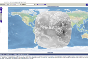 Map Viewer that allows downloading and time series creation of meteosat products.Publishing institution:
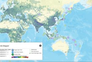 The Hazards Mapper home page is a base map of the world with darker shaded areas indicating higher population densities. Custom population estimates generated by the Hazards Mapper are provided by SEDAC’s Population Estimation Service (PES). Population and settlement data are based on SEDAC’s Global Rural-Urban Mapping Project (GRUMP) and Gridded Population of the World, version 3 (GPWv3) data collections. GPWv3 provides a resolution of roughly 4 km (2.5 miles) at the equator. This population resolution will increase significantly when the updated version, GPWv4, is released in 2016. “Our new population layer will be at a resolution of 1 km (0.6 miles) at the equator, which will give higher precision for smaller areas,” says de Sherbinin.
Continuously updated data layers that can be overlaid on the base map are available from NASA’s EOSDIS, including data from SEDAC; NASA's Land, Atmosphere Near real-time Capability for EOS (LANCE); and Global Imagery Browse…, The default base map includes:
Red dots indicating fires and other hotspots detected over the past 48 hours by NASA’s Moderate Resolution Imaging Spectroradiometer (MODIS) instrument;
Colored circles indicating earthquakes over the past seven days from the USGS Earthquake Hazards Program;
Icons indicating the location of individual dams, dam clusters, and nuclear power plants from SEDAC’s Global Reservoir and Dam and Population Exposure Estimates in Proximity to Nuclear Power Plants, Locations databases; and,
Colored polygons indicating tornado and flood warnings issued by NOAA (U.S. locations only).
Publishing institution: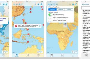 Hazards and Population Mapper (HazPop) is a free app that enables users to easily display recent natural hazard data in relationship to population, major infrastructure, and satellite imagery. Hazards data include the location of active fires over the past 48 hours; earthquake alerts over the past seven days; and yesterday′s air pollution data measured from space. The app shows the location of major dams and nuclear power plants and provides more detailed information and imagery for these facilities where available. By drawing a circle around a point or area of interest on the map, users can obtain an estimate of the total population and land area enclosed within., Developed by the NASA Socioeconomic Data and Applications Center (SEDAC) operated by the Center for International Earth Science Information Network (CIESIN) at Columbia University, HazPop combines data and map layers from various sources including NASA's Land, Atmosphere Near real-time Capability for EOS (LANCE) and Global Imagery Browse Services (GIBS), the U.S. Geological Survey (USGS), and others using a variety of open Web mapping services. The custom population estimates are provided by the SEDAC Population Estimation Service (PES) based on SEDAC′s Gridded Population of the World, version 4 (GPWv4) data for 2015.Publishing institution:
") Publishing institution:
Publishing institution:
The Asia and Oceania regions are frequently affected by severe natural phenomena such as tropical cyclones, torrential monsoons, volcanic eruptions, yellow sandstorms, floods, sea ice, and wildfires. The importance of monitoring the climate and the environment is also increasing, which has prompted enhanced global interest in the field.
In this area, the new generation of meteorological and earth observation satellites provide frequent and extensive observational information for use in disaster prevention and climate monitoring/diagnostics; they are indispensable in today’s world. The Asia/Oceania Meteorological Satellite Users’ Conferences provide an excellent forum for satellite operators and users within the Asia/Oceania community to meet and enhance their joint efforts in the utilization of satellite data and products for better weather, climate, and disaster mitigation services.Objectives- Promoting satellite…
 Publishing institution:
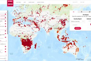 The Global Forest Watch Fires is a dynamic online forest monitoring and fire alert system that provides near real time information to enable people to better combat forest and land fires before they burn out of control.Publishing institution:
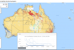
The Australian Flammability Monitoring System is a new vegetation condition and flammability online mapping tool that is expected to support fire and land managers in Australia.
The mapping tool uses satellite data to collect information on moisture content in highly flammable vegetation such as fallen bark, leaf litter and grass. It then displays this information on an interactive map, which will help fire managers in determining burning efforts and preparing of firefighting resources.
A team of researchers from the Australian National University (ANU) developed the monitoring tool - the first web-based system of its kind in Australia - as part of the Mapping bushfire hazards and impacts research project with the Bushfire and Natural Hazards CRC.
… read more20/09/2018
Term Parents
UN-SPIDER Regional Support Offices with hazard-specific expertise
![]()