![]()
United
Nations
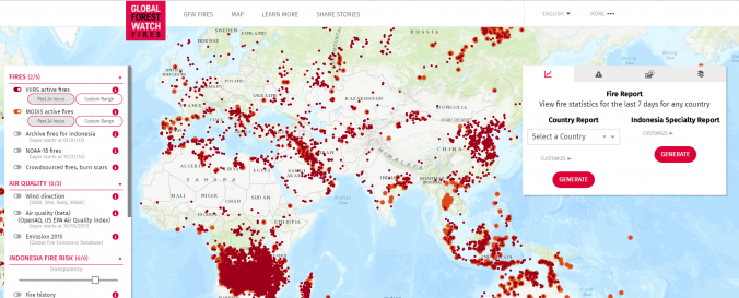
Global Forest Watch Fires (WRI)
| Data provided by: | World Resources Institute (WRI) |
| Data accessibility: | export data, statistical data (e.g. graphs), visualization of data (e.g. web GIS or real time monitoring) |
| Link to the data: | |
| Data type: | hazard specific data |
| Hazard: | Forest Fire |
| Disaster cycle phase: | Disaster Risk Management, Response, Recovery |
| Space-based Information: | The Global Forest Watch Fires is a dynamic online forest monitoring and fire alert system that provides near real time information to enable people to better combat forest and land fires before they burn out of control. |
| Satellites and Sensors: | Sentinel-2A, Landsat 4 |
| Spatial coverage: | Global |
| Spatial resolution: | 10m-30m |
| Temporal coverage: | Archive, Near-real time |
| Content dates: | Active Fire Data is available near real time, information on past fires is available from ~2013. Dates of background and statistical data sets vary. |
| Technical Specifications: | |
| Costs: | free |
| Contact: | Fires Global Forest Watch |
| Tutorials on the use of data: | Tutorial Videos, Visualize Fire Data |
Provider
![]()