![]()
United
Nations
Sécheresse
 instrument aboard ESA’s Envisat satellite. Image: ESA, CC BY-SA 3.0 IGO.")
Definition
Facts and figures
Further information
UN-SPIDER Regional Support Offices with hazard-specific expertise
Related content on the Knowledge Portal
 Publishing institution:
 The Copernicus Open Access Hub provides complete, free and open access to Sentinel missions data.Publishing institution:
- Publishing institution:

This introductory webinar will cover the fundamentals of Solar Induced Fluorescence (SIF) and LIDAR, their applications, and an overview of different satellite data sources that are openly available. In addition, it will also include a step-by-step guide on how to access, open, and interpret SIF and LIDAR data.
SIF is a relatively new satellite retrieval, providing a direct measurement related to plant photosynthetic activity. It serves as a strong proxy to gross primary production (GPP), capturing dynamic responses of vegetation to stressors such as drought and temperature.
LIDAR is a system that illuminates a target and measures distance through the time taken for a pulse to reflect back to the sensor. LIDAR can be used to generate topography and vegetation height maps and retrieve digital elevation data necessary for flood modeling and vulnerability, along with risk analysis. They are valuable datasets for post-disaster assessment of debris deposition,…
read more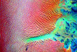

To continue efforts to make use of the opportunities made available by the space community, UN-SPIDER, NASRDA, NEMA and the Centre for Remote Sensing of Land Surfaces of the University of Bonn (ZFL) joined forces to carry out the UN-SPIDER/NASRDA/NEMA/ZFL National Virtual Expert Meeting on the use of Space-based Solutions for Disaster Risk Management and Emergency Response in Nigeria. The virtual expert meeting focused on the use of space technologies to improve disaster risk reduction in Nigeria. Specifically, the goal of the meeting was to contribute to the efforts conducted by NEMA in the area of disaster risk reduction, preparedness, early warning systems, disaster response and recovery efforts. Outcomesof this Expert Meeting included, but were not limited to:
- Enhancing space-based disaster management efforts in Nigeria
- Improving capacity to use earth observation data to manage disasters in Nigeria
- Raising…
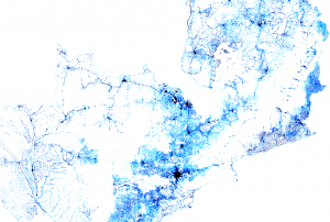 Facebook Connectivity Lab in collaboration with the Center for International Earth Science Information Network (CIESIN) at Colombia University combines machine vision AI with satellite imagery and census information to create population density maps. With the integration of demographic information, specifically related to age and gender, these maps collectively provide information on both the location and the demographic of a population in a certain country. The population density maps cover the majority of countries around the world.Publishing institution:
-
Facebook Connectivity Lab in collaboration with the Center for International Earth Science Information Network (CIESIN) at Colombia University combines machine vision AI with satellite imagery and census information to create population density maps. With the integration of demographic information, specifically related to age and gender, these maps collectively provide information on both the location and the demographic of a population in a certain country. The population density maps cover the majority of countries around the world.Publishing institution:

Having reliable and timely population distribution data can make a life or death difference for individuals facing crises or living in conflict-ridden regions. These data are also essential for development decision-making and planning and for monitoring progress towards the UN Sustainable Development Goals (SDGs) established by the international community. We need to know where people are located, what conditions they are facing, what infrastructure is available, and what basic services they can access. We also need to ensure that no one is left off the map in pursuit of meeting the SDGs.
Gridded population data, which often use remote sensing inputs to improve the spatial allocation of population within a country, are vital for all these purposes. Together with the growing variety of applications that require spatial population data, there is now a bewildering array of population grids, and users need to know which ones are most suitable for their applications…
read more
Term Parents
UN-SPIDER Regional Support Offices with hazard-specific expertise
![]()